IMAGES TAKEN NEAR TO
Heol Llaindelyn, CARMARTHEN, SA33 4BB
Introduction
This page details the photographs taken nearby to Heol Llaindelyn, SA33 4BB by members of the Geograph project.
The Geograph project started in 2005 with the aim of publishing, organising and preserving representative images for every square kilometre of Great Britain, Ireland and the Isle of Man.

There are currently over 7.5m images from over14,400 individuals and you can help contribute to the project by visiting https://www.geograph.org.uk
Image Map
Images are licensed for reuse under creativecommons.org/licenses/by-sa/2.0
Notes
- Clicking on the map will re-center to the selected point.
- The higher the marker number, the further away the image location is from the centre of the postcode.
Image Listing (14 Images Found)
Images are licensed for reuse under creativecommons.org/licenses/by-sa/2.0
Image
Details
Distance
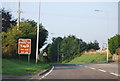
1
Heol Llaindelyn / Bethlehem Raod
Heol Llaindelyn yn mynd i gyfeiriad San Cler.
Bethlehem Road heading towards St Clears.
Image: © Alan Richards
Taken: 2 Mar 2023
0.04 miles
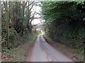
2
Heol Llaindelyn / Bethlehem Raod
Heol Llaindelyn yn mynd i gyfeiriad San Cler.
Bethlehem Road heading towards St Clears
Image: © Alan Richards
Taken: 2 Mar 2023
0.04 miles
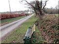
4
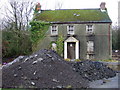
Derelict house on a roundabout
I've often wondered about the story behind this old house which stands just feet away from a busy roundabout west of Sancler/St Clears. On the older maps there was simply a crossroads on the A40 here, now there is noisy traffic night and day and the silent dereliction of this building contrasts oddly with the fast food restaurant opposite and other drive-in commercial outlets nearby.
Image: © Natasha Ceridwen de Chroustchoff
Taken: 28 Dec 2006
0.12 miles
5
Derelict house on a roundabout
The A40 outside St Clears is not the ideal place to live so I am not surprised the house is empty.
Image: © Jeff Gogarty
Taken: 4 Jun 2016
0.14 miles
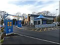
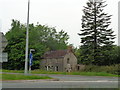
6
Esso Petrol Station near St Clears
The shop and petrol station on the A477, near St Clears.
Image: © Martyn Harries
Taken: 14 Aug 2011
0.15 miles
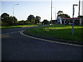
8
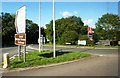
Road junction at St Clears
Junction of the A477 and the A4066 on roundabout at St Clears. Car park for Little Chef visible in background.
Image: © Clint Mann
Taken: 19 Aug 2014
0.16 miles
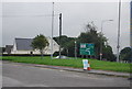
9
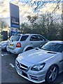
Travelodge car park
Car park at the Travelodge, St Clears.
Image: © Alan Hughes
Taken: 19 Nov 2018
0.17 miles