IMAGES TAKEN NEAR TO
Phillips Field, SWANSEA, SA3 2EP
Introduction
This page details the photographs taken nearby to Phillips Field, SA3 2EP by members of the Geograph project.
The Geograph project started in 2005 with the aim of publishing, organising and preserving representative images for every square kilometre of Great Britain, Ireland and the Isle of Man.

There are currently over 7.5m images from over14,400 individuals and you can help contribute to the project by visiting https://www.geograph.org.uk
Image Map
Images are licensed for reuse under creativecommons.org/licenses/by-sa/2.0
Notes
- Clicking on the map will re-center to the selected point.
- The higher the marker number, the further away the image location is from the centre of the postcode.
Image Listing (53 Images Found)
Images are licensed for reuse under creativecommons.org/licenses/by-sa/2.0
Image
Details
Distance
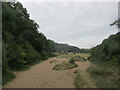
4
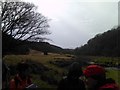
Sand dunes alongside the Pennard Pill
Looking southwest.
Image: © Robert Lamb
Taken: 18 Mar 2011
0.11 miles
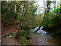
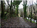
6

Footpath through woodland alongside Pennard Pill
The footpath leads from the village of Parkmill towards Three Cliffs Bay.
Image: © Alan Hughes
Taken: 23 Dec 2019
0.11 miles
7
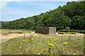
Concrete Building in the Sand
I don't know what this is. "WW2 Remnant" is the usual tag for old concrete stuff like this, but it might not be that.
Image: © Des Blenkinsopp
Taken: 22 Jul 2021
0.11 miles
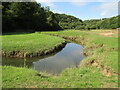
8
Pennard Pill
Wikipedia says "Pîl (also rendered as Pill, Pil or Pyll) is a Welsh placename element. The name is defined as the tidal reach of a waterway, suitable as a harbour, but is only common along the Bristol Channel and Severn Estuary. The highly localised distribution suggests it may have only been applicable to waterways within the tidal reach of the Severn sea."
Pennard Pill meets the sea in a wide cove which may well have been a sheltered beaching place for small boats at one time.
Image: © Des Blenkinsopp
Taken: 22 Jul 2021
0.11 miles
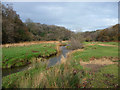
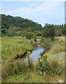
9
Parkmill - Pennard Pill
Meandering stream just north of Three Cliffs Bay.
Image: © Colin Smith
Taken: 2 Sep 2018
0.11 miles
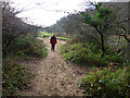
10
Sandy path to Three Cliffs Bay
Hard to walk on a very hot day.
Image: © steven ruffles
Taken: 29 Jul 2022
0.12 miles