IMAGES TAKEN NEAR TO
Dryslwyn, CARMARTHEN, SA32 8RG
Introduction
This page details the photographs taken nearby to SA32 8RG by members of the Geograph project.
The Geograph project started in 2005 with the aim of publishing, organising and preserving representative images for every square kilometre of Great Britain, Ireland and the Isle of Man.

There are currently over 7.5m images from over14,400 individuals and you can help contribute to the project by visiting https://www.geograph.org.uk
Image Map
Images are licensed for reuse under creativecommons.org/licenses/by-sa/2.0
Notes
- Clicking on the map will re-center to the selected point.
- The higher the marker number, the further away the image location is from the centre of the postcode.
Image Listing (6 Images Found)
Images are licensed for reuse under creativecommons.org/licenses/by-sa/2.0
Image
Details
Distance
1
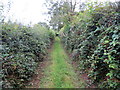
Heol las ger Penycoed / A green lane near Penycoed
Heol las ddymunol ger Ffarm Penycoed.
A pleasant green road near Penycoed Farm (trans. end of the wood).
Image: © Alan Richards
Taken: 23 Aug 2020
0.18 miles
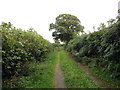
2
Heol las ger Penycoed / A green lane near Penycoed
Heol las ddymunol ger Ffarm Penycoed.
A pleasant green lane near Penycoed Farm (trans. end of the wood).
Image: © Alan Richards
Taken: 23 Aug 2020
0.19 miles
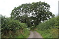
3
Heol las ger Penycoed / A green lane near Penycoed
Heol las yn agosau at ffordd fach ger Ffarm Penycoed.
A green lane approaching a minor road near Penycoed Farm (trans. end of the wood).
Image: © Alan Richards
Taken: 23 Aug 2020
0.20 miles
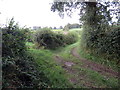
5
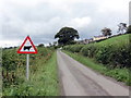
Heol fach ger Ffarm y Twyn / Minor road near Twyn Farm
Heol fach ger Twyn, enw'r ffarm yn y pellter.
A minor road near Twyn (trans. hillock), the name of the farm in the distance.
Image: © Alan Richards
Taken: 23 Aug 2020
0.23 miles
6
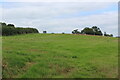
Grass field above A40, Llanon Road
Field at crossroad.
Image: © M J Roscoe
Taken: 25 Aug 2021
0.24 miles