IMAGES TAKEN NEAR TO
Brechfa, CARMARTHEN, SA32 7QS
Introduction
This page details the photographs taken nearby to SA32 7QS by members of the Geograph project.
The Geograph project started in 2005 with the aim of publishing, organising and preserving representative images for every square kilometre of Great Britain, Ireland and the Isle of Man.

There are currently over 7.5m images from over14,400 individuals and you can help contribute to the project by visiting https://www.geograph.org.uk
Image Map
Images are licensed for reuse under creativecommons.org/licenses/by-sa/2.0
Notes
- Clicking on the map will re-center to the selected point.
- The higher the marker number, the further away the image location is from the centre of the postcode.
Image Listing (2 Images Found)
Images are licensed for reuse under creativecommons.org/licenses/by-sa/2.0
Image
Details
Distance
1
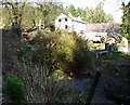
In the Middle of a Forest
This property is shown as being in an open space surrounded by forestry.
It isn't!
Image: © Dara Jasumani
Taken: 9 Apr 2006
0.02 miles
2
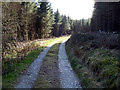
Open Space
This is shown as a large clearing on the map. And it's not really a recent plantation is it.
Image: © Dara Jasumani
Taken: 9 Apr 2006
0.15 miles