IMAGES TAKEN NEAR TO
Nantgaredig, CARMARTHEN, SA32 7LH
Introduction
This page details the photographs taken nearby to SA32 7LH by members of the Geograph project.
The Geograph project started in 2005 with the aim of publishing, organising and preserving representative images for every square kilometre of Great Britain, Ireland and the Isle of Man.

There are currently over 7.5m images from over14,400 individuals and you can help contribute to the project by visiting https://www.geograph.org.uk
Image Map
Images are licensed for reuse under creativecommons.org/licenses/by-sa/2.0
Notes
- Clicking on the map will re-center to the selected point.
- The higher the marker number, the further away the image location is from the centre of the postcode.
Image Listing (9 Images Found)
Images are licensed for reuse under creativecommons.org/licenses/by-sa/2.0
Image
Details
Distance
1
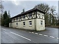
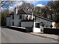
Y Polyn
A small, family-owned restaurant.
https://www.ypolyn.co.uk/
Image: © Alan Hughes
Taken: 15 Feb 2021
0.01 miles
3
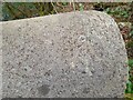
Ordnance Survey Rivet
This OS rivet can be found on the bridge east side of the road. It marks a point 68.359m above mean sea level.
Image: © Adrian Dust
Taken: 10 Apr 2022
0.01 miles
5
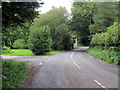
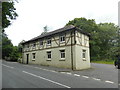
Cyffordd ger Tafarn y Polyn / Junction near Y Polyn public house
Cyffordd ar y chwith uwchlaw Tafarn y Polyn a welir yn y pellter.
A junction on the left above Y Polyn public house (trans. the pole) visible in the distance.
Image: © Alan Richards
Taken: 26 Aug 2020
0.05 miles
6
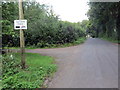
Heol ger pysgodfa / Road near a fishery
Heol yn mynd heibio i fynedfa Pysgodfa Pen y Bedw.
A road passing the entrance to Pen y Bedw Fishery (trans. end of the birch trees).
Image: © Alan Richards
Taken: 26 Aug 2020
0.10 miles
9
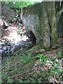
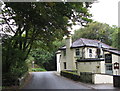
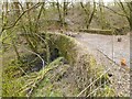
Redundant Bridge
This Bridge carried the B4300 until the road was straightened and widened at this point. The road now runs by to the north. Now overgrown and lost in the trees.
Image: © Adrian Dust
Taken: 2 Jun 2013
0.19 miles