IMAGES TAKEN NEAR TO
Whitemill, CARMARTHEN, SA32 7EY
Introduction
This page details the photographs taken nearby to SA32 7EY by members of the Geograph project.
The Geograph project started in 2005 with the aim of publishing, organising and preserving representative images for every square kilometre of Great Britain, Ireland and the Isle of Man.

There are currently over 7.5m images from over14,400 individuals and you can help contribute to the project by visiting https://www.geograph.org.uk
Image Map
Images are licensed for reuse under creativecommons.org/licenses/by-sa/2.0
Notes
- Clicking on the map will re-center to the selected point.
- The higher the marker number, the further away the image location is from the centre of the postcode.
Image Listing (6 Images Found)
Images are licensed for reuse under creativecommons.org/licenses/by-sa/2.0
Image
Details
Distance
2

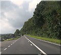
A40 at Danyrallt
The farm at Danyrallt is just off to the right. Before the right bend ahead, the road has crossed into Image
Image: © Derek Harper
Taken: 2 Jan 2015
0.18 miles
3
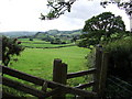
View towards Carmarthen
The footpath follows the hedge on the right
Image: © Alistair Hare
Taken: 19 Jun 2011
0.20 miles
4
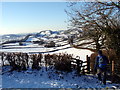
Ger / Near Waun yr Afr
Llwybr cyhoeddus ger Ffarm Waun yr Afr.
Public footpath near Waun yr Afr (trans. goat meadow).
Image: © Alan Richards
Taken: 3 Jan 2010
0.21 miles
5
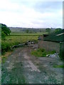
Danyrallt Farm
Cows coming in for milking near Nantgaredig.
Image: © Burgess Von Thunen
Taken: 29 May 2011
0.24 miles
6
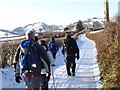
Tuag at / Towards Penybryn
Cerddwyr yn dilyn heol tuag at Ffarm Pen y Bryn yn y pellter.
Walkers following the road in the direction of Pen y Bryn Farm (trans. top of the hill) in the distance.
Image: © Alan Richards
Taken: 3 Jan 2010
0.24 miles