IMAGES TAKEN NEAR TO
Llanmadoc, SWANSEA, SA3 1DL
Introduction
This page details the photographs taken nearby to SA3 1DL by members of the Geograph project.
The Geograph project started in 2005 with the aim of publishing, organising and preserving representative images for every square kilometre of Great Britain, Ireland and the Isle of Man.

There are currently over 7.5m images from over14,400 individuals and you can help contribute to the project by visiting https://www.geograph.org.uk
Image Map
Images are licensed for reuse under creativecommons.org/licenses/by-sa/2.0
Notes
- Clicking on the map will re-center to the selected point.
- The higher the marker number, the further away the image location is from the centre of the postcode.
Image Listing (44 Images Found)
Images are licensed for reuse under creativecommons.org/licenses/by-sa/2.0
Image
Details
Distance
1
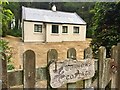
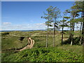
Burrows Cottage
Burrows Cottage is a simple, single-storey former forester’s cottage now used as a bunk house by the National Trust. Located in a secluded spot alongside a pine wood below Cwm Ivy Tor.
Image: © Alan Hughes
Taken: 23 Jul 2018
0.00 miles
2
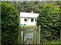
Bwthyn y Twyni/Burrows Cottage
National Trust owned former forester's cottage available to hire for holiday accommodation
Image: © Eirian Evans
Taken: 20 May 2022
0.00 miles
3
Cwm Ivy
On the edge of the south-west wooded area of Whiteford National Nature Reserve, near Cwm Ivy.
Image: © Daniel Giddy
Taken: 9 Dec 2003
0.03 miles
4
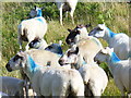
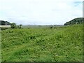
Welsh Lamb at Cwm Ivy
Sheep grazing is a common sight on the local freshwater and salt marshes and on the grassy limestone hill areas.
Image: © Colin Smith
Taken: 24 Jul 2009
0.07 miles
5
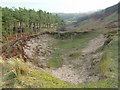
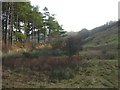
Cwm Ivy
Sand dune erosion at the south-western point of Whiteford National Nature Reserve, with the slope of Cwm Ivy Tor to the right.
Image: © Daniel Giddy
Taken: 9 Dec 2003
0.07 miles
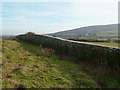
6
Llanmadoc: the slopes of Cwm Ivy Tor
Looking north from by the church, across the gentle green slopes of this rocky crop by the Loughor estuary, which we see to the right along with the sands of the far shore.
Image: © Chris Downer
Taken: 1 Feb 2010
0.10 miles
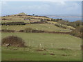
7
Cwm Ivy Tor
View towards the village of Llanmadoc and Llanmadoc Hill, with a boundary wall on Cwm Ivy Tor.
Image: © Daniel Giddy
Taken: 9 Dec 2003
0.10 miles
8
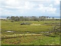
Cwm Ivy marsh
The marsh at Cwm Ivy appears to have been an attempt at reclaimation as there is a sea wall at the far side. I believe the sea wall has recently been breached, thus allowing the ingress of sea water, which might help explain why the distant trees look rather sickly.
Image: © Gordon Hatton
Taken: 30 Sep 2016
0.10 miles
9
Whiteford Burrows
A large sand dune system which has been stabilised by grasses and pine stands.
Image: © Colin Smith
Taken: 7 Sep 2018
0.11 miles
10
View to Cwm Ivy Marsh
The dead trees are a ghostly remains of when this area was separated from the sea by a sea wall. As a result of saltwater reclaiming the land following a breach in the sea wall, the trees and farmland grasses died and saltwater tolerant species returned to the marsh.
Image: © Eirian Evans
Taken: 20 May 2022
0.12 miles