IMAGES TAKEN NEAR TO
Llanmadoc, SWANSEA, SA3 1DE
Introduction
This page details the photographs taken nearby to SA3 1DE by members of the Geograph project.
The Geograph project started in 2005 with the aim of publishing, organising and preserving representative images for every square kilometre of Great Britain, Ireland and the Isle of Man.

There are currently over 7.5m images from over14,400 individuals and you can help contribute to the project by visiting https://www.geograph.org.uk
Image Map
Images are licensed for reuse under creativecommons.org/licenses/by-sa/2.0
Notes
- Clicking on the map will re-center to the selected point.
- The higher the marker number, the further away the image location is from the centre of the postcode.
Image Listing (63 Images Found)
Images are licensed for reuse under creativecommons.org/licenses/by-sa/2.0
Image
Details
Distance
1
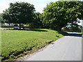
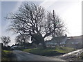
The village green in Llanmadoc
The old village green remains in the centre of the village, raised above the road and surmounted by a Horse-Chestnut tree to the right. The large imposing white house is the old vicarage.
Image: © Jeremy Bolwell
Taken: 6 Jun 2011
0.01 miles
2
Small green in Llanmadoc
At the western end of the village.
Image: © Bill Boaden
Taken: 9 Apr 2016
0.02 miles
3
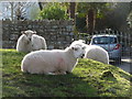
Llanmadoc: lazing sheep
The sheep on this small green triangle appeared to fall into one of two rhyming categories: grazing and lazing. These were currently occupying the latter.
Image: © Chris Downer
Taken: 1 Feb 2010
0.02 miles
4
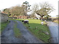
Llanmadoc: sheep on green triangle
These sheep – one black one among them – are grazing on a green patch separating a driveway from the main road.
Image: © Chris Downer
Taken: 1 Feb 2010
0.03 miles
5
Llanmadoc: a large tree
Looking into the sun and towards a green triangle of land, which hosts a large tree with sheep grazing around it.
Image: © Chris Downer
Taken: 1 Feb 2010
0.03 miles
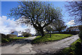
6
Llanmadoc: choice of dead ends
There is nowhere else to go once you get here – we are at the far end of the Gower peninsula. However, both routes will take you to pleasant walks to the wide sandy beaches of the Loughor estuary.
Image: © Chris Downer
Taken: 1 Feb 2010
0.05 miles
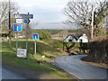
7
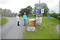
Road Signs at Llanmadoc
The minor road on the right descends to the hamlet of Cwm Ivy. Other signs at this road junction advertise a craft shop, accommodation, fishing bait, a camping site and cafe, two car parks and a warning about dog fouling.
Image: © Nigel Mykura
Taken: 27 Jun 2015
0.05 miles
8
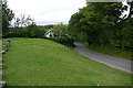
The Road to Cwm Ivy
This is the small lane that descends from Llanmadoc village to Cwm Ivy. It is a dead end and the green grassy bank in the foreground is part of the approach to Llanmadoc Church.
Image: © Nigel Mykura
Taken: 27 Jun 2015
0.07 miles
9
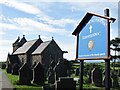
Llanmadoc - Parish Church
St Madoc's church is Norman, rebuilt in the 13th century, but restored in the 1800's.
Image: © Colin Smith
Taken: 7 Sep 2018
0.07 miles
10
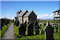
St Madoc's Church, Llanmadoc
With views out to Carmarthen Bay beyond.
Image: © Bill Boaden
Taken: 9 Apr 2016
0.07 miles