IMAGES TAKEN NEAR TO
Burry, Reynoldston, SWANSEA, SA3 1BH
Introduction
This page details the photographs taken nearby to SA3 1BH by members of the Geograph project.
The Geograph project started in 2005 with the aim of publishing, organising and preserving representative images for every square kilometre of Great Britain, Ireland and the Isle of Man.

There are currently over 7.5m images from over14,400 individuals and you can help contribute to the project by visiting https://www.geograph.org.uk
Image Map
Images are licensed for reuse under creativecommons.org/licenses/by-sa/2.0
Notes
- Clicking on the map will re-center to the selected point.
- The higher the marker number, the further away the image location is from the centre of the postcode.
Image Listing (7 Images Found)
Images are licensed for reuse under creativecommons.org/licenses/by-sa/2.0
Image
Details
Distance
1
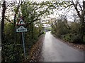
Treflan Burry Hamlet
Cyrraedd Treflan fach Burry.
Arriving at the small hamlet of Burry.
Image: © Alan Richards
Taken: 22 Nov 2014
0.17 miles
2
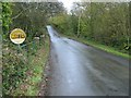
Bridge over Burry Pill
This bridge bears an unusual sign with the word "WATER" surrounded by "Glamorgan Fire Service" in a semicircle.
Image: © Nigel Davies
Taken: 7 Nov 2009
0.19 miles
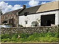
3
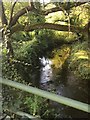
Burry Pill
Stream flowing under the road near Burry Farm.
Image: © Alan Hughes
Taken: 25 Sep 2018
0.21 miles
4
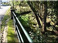
Burry Pill
The bridge over this small stream is well built. On each side of the road is a row of solid stone piers supporting heavy railings.
Image: © Chris Henley
Taken: 18 Oct 2006
0.21 miles
5
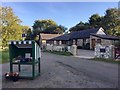
Burry Farm
Honesty stall with home grown produce for sale at Burry Farm.
Image: © Alan Hughes
Taken: 25 Sep 2018
0.22 miles
7
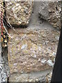
Ordnance Survey Cut Mark
This OS cut mark can be found on an outbuilding at Middle Mill. It marks a point 29.304m above mean sea level.
Image: © Adrian Dust
Taken: 7 Jun 2014
0.22 miles