IMAGES TAKEN NEAR TO
Penllwyn Park, CARMARTHEN, SA31 3BU
Introduction
This page details the photographs taken nearby to Penllwyn Park, SA31 3BU by members of the Geograph project.
The Geograph project started in 2005 with the aim of publishing, organising and preserving representative images for every square kilometre of Great Britain, Ireland and the Isle of Man.

There are currently over 7.5m images from over14,400 individuals and you can help contribute to the project by visiting https://www.geograph.org.uk
Image Map
Images are licensed for reuse under creativecommons.org/licenses/by-sa/2.0
Notes
- Clicking on the map will re-center to the selected point.
- The higher the marker number, the further away the image location is from the centre of the postcode.
Image Listing (105 Images Found)
Images are licensed for reuse under creativecommons.org/licenses/by-sa/2.0
Image
Details
Distance
1
Festive tree with Picton Monument
A very suitable festive decoration that fits the monument shape.
Image: © chris whitehouse
Taken: 14 Dec 2012
0.02 miles
2
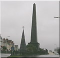
The Picton Monument
The original monument, erected in 1828, stood at the west end of the town and was erected in memory of Sir Thomas Picton, who died in the Battle of Waterloo. Unfortunately, this monument fell into a dilapidated state within a few years and the monument was dismantled in 1846.
The foundation stone of the current monument standing at the top of Monument Hill was laid in 1847. In 1988, the whole monument was rebuilt stone-by-stone on new stronger foundations.
Image: © David Dixon
Taken: 8 Sep 2011
0.02 miles
3
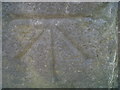
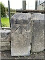
Ordnance Survey Benchmark - Carmarthen, Picton's Monument
Ordnance Survey Benchmark (OSBM) used for levelling height above Ordnance Datum (OD).
Height: 30.2588m OD (Newlyn). Mark verified by the Ordnance Survey in 1976. Description: WALL NE ANG PICTON MON N FACE. 0.5m above ground. 3rd Order BM.
The mark was used on the Llanstephan to Dolfor Toll-house line of the First Primary Levelling of England & Wales in 1856-1857. It was levelled with a height of 99.615' above OD (Liverpool). Description: 17. Mark on base of railing enclosing Picton's Monument ; 2.07 ft. above surface. Page 576 of the abstract: http://www.bench-marks.org.uk/ew1gl/1GLA_576.png
Context: Image
Image: © N Scott
Taken: 8 Oct 2013
0.02 miles
4
Ordnance Survey Benchmark - Carmarthen, Picton's Monument
Ordnance Survey Benchmark (OSBM) used for levelling height above Ordnance Datum (OD).
Height: 30.2588m OD (Newlyn). Mark verified by the Ordnance Survey in 1976. Description: WALL NE ANG PICTON MON N FACE. 0.5m above ground. 3rd Order BM.
The mark was used on the Llanstephan to Dolfor Toll-house line of the First Primary Levelling of England & Wales in 1856-1857. It was levelled with a height of 99.615' above OD (Liverpool). Description: 17. Mark on base of railing enclosing Picton's Monument ; 2.07 ft. above surface. Page 576 of the abstract: http://www.bench-marks.org.uk/ew1gl/1GLA_576.png
Close=up: Image
Image: © N Scott
Taken: 8 Oct 2013
0.02 miles
5
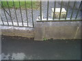
OS Cut Mark - Carmarthen, Picton Monument
https://www.bench-marks.org.uk/bm30920
Image: © thejackrustles
Taken: 9 Oct 2022
0.02 miles
6
Location of OS Cut Mark - Carmarthen, Picton Monument
Image: © thejackrustles
Taken: 9 Oct 2022
0.02 miles
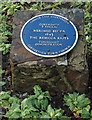
8
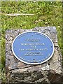
The Rebecca Riots Plaque
https://openplaques.org/plaques/41797
https://www.nationalarchives.gov.uk/education/resources/rebecca-riots/
The Rebecca riots took place in the rural parts of west Wales, including Pembrokeshire, Cardiganshire, and Carmarthenshire, in 1839-1843. They were a series of protests made by tenant farmers against the payment of tolls (fees) charged to use the roads. Turnpike Trusts, or groups of businessmen, owned most of the main roads. These men fixed the charges and decided how many tollgates (turnpikes) could be built.
During the riots, men disguised as women attacked the tollgates. They called themselves ‘Rebecca and her daughters’. This is most likely to be after a passage in the Bible where Rebecca talks of the need to ‘possess the gates of those who hate them’ (Genesis XXIV, verse 60). People at that time knew the Bible well.
Tolls were a big expense for small farmers, who used the roads to take their crops and animals to market, and also to collect lime (a chalky mineral). Lime was used to improve the quality of the soil so farmers could grow better crops. It could cost as much as five shillings (25p) in tolls to move a cart of lime eight miles inland. The people of west Wales did not want to pay to use their roads. Use this lesson to find out about the Rebecca riots using original documents relating to the nature of the movement, the experience of some of those involved and the reaction of the authorities.
Image: © thejackrustles
Taken: 9 Oct 2022
0.02 miles
10
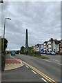
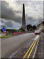
Picton Memorial
Memorial to Lieutenant General Sir Thomas Picton, the most senior officer killed at the battle of Waterloo
Image: © thejackrustles
Taken: 9 Oct 2022
0.03 miles