IMAGES TAKEN NEAR TO
Brynderwen, CARMARTHEN, SA31 2HF
Introduction
This page details the photographs taken nearby to Brynderwen, SA31 2HF by members of the Geograph project.
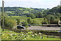
The Geograph project started in 2005 with the aim of publishing, organising and preserving representative images for every square kilometre of Great Britain, Ireland and the Isle of Man.

There are currently over 7.5m images from over14,400 individuals and you can help contribute to the project by visiting https://www.geograph.org.uk
Image Map (Loading...)


Getting Data...Please wait
Leaflet Map data © OpenStreetMap
Images are licensed for reuse under creativecommons.org/licenses/by-sa/2.0
Notes
- Clicking on the map will re-center to the selected point.
- The higher the marker number, the further away the image location is from the centre of the postcode.
Image Listing (60 Images Found)
Images are licensed for reuse under creativecommons.org/licenses/by-sa/2.0
Image
Details
Distance
1
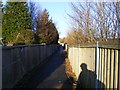
Footpath alongside the A40(T)
Footpath from Tanerdy to Abergwilli Road near to the A40(T) overpass.
Image: © Alan Harris
Taken: 16 Feb 2010
0.03 miles
2
Cycle lane down to side of A40
NCR 47 descends to the side of the dual carriageway; whilst a footpath goes to the right out of shot.
Image: © M J Roscoe
Taken: 25 Aug 2021
0.05 miles
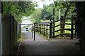
3
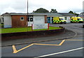
Carmarthen Ambulance Station
The Welsh Ambulance Services NHS Trust station is located on the north side of Abergwili Road.
Image: © Jaggery
Taken: 12 Aug 2012
0.06 miles
4
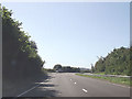
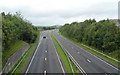
Large layby on A40 westbound
Carmarthen by pass near Tanerdy
Image: © John Firth
Taken: 5 Sep 2012
0.08 miles
5
Vehicles in lay-by on A40
Lay-by on southwest bound side of dual carriageway; The fence bordering the cycle lane, NCR 47, can be seen in the foreground.
Image: © M J Roscoe
Taken: 25 Aug 2021
0.08 miles
6
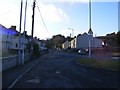
Heol Abergwili / Abergwili Road
View of Abergwili Road, Carmarthen, looking towards the Tanerdy Roundabout. To the left is the entrance to the footpath alongside the A40(T) towards Parc Hinds, Carmarthen.
Image: © Alan Harris
Taken: 16 Feb 2010
0.08 miles
7
A40 heads SW away from the Abergwili Road bridge, Carmarthen
The route of the A40 here was formerly a railway line. At that time, the route of the A40 was Abergwili Road, from where this view was taken.
Image: © Jaggery
Taken: 12 Aug 2012
0.08 miles
8
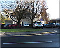
Glangwili Day Nursery, Carmarthen
Day nursery and creche viewed across the A484 Bronwydd Road.
Image: © Jaggery
Taken: 18 Nov 2019
0.08 miles
9
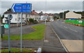
Turn left here for National Cycle Route 47, Carmarthen
Viewed along Abergwili Road. The sign points left towards cycle route 47. Helpfully, the cycling time (9 minutes) and walking time (31 minutes) to the railway station and town centre are shown.
The green wall on the right is part of a building site. http://www.geograph.org.uk/photo/3082914
Image: © Jaggery
Taken: 12 Aug 2012
0.09 miles
10
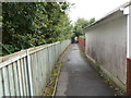
Cycle route 47, Carmarthen
A sign http://www.geograph.org.uk/photo/3082921 a few metres behind the camera shows that this is part of National Cycle Network Route 47, and also a footpath. Cycling time to Carmarthen town centre and railway station is 9 minutes. Walking time is 31 minutes. Most of the route ahead is alongside the A40.
Image: © Jaggery
Taken: 12 Aug 2012
0.09 miles