IMAGES TAKEN NEAR TO
Tanerdy, CARMARTHEN, SA31 2EY
Introduction
This page details the photographs taken nearby to Tanerdy, SA31 2EY by members of the Geograph project.
The Geograph project started in 2005 with the aim of publishing, organising and preserving representative images for every square kilometre of Great Britain, Ireland and the Isle of Man.

There are currently over 7.5m images from over14,400 individuals and you can help contribute to the project by visiting https://www.geograph.org.uk
Image Map (Loading...)


Getting Data...Please wait
Leaflet Map data © OpenStreetMap
Images are licensed for reuse under creativecommons.org/licenses/by-sa/2.0
Notes
- Clicking on the map will re-center to the selected point.
- The higher the marker number, the further away the image location is from the centre of the postcode.
Image Listing (54 Images Found)
Images are licensed for reuse under creativecommons.org/licenses/by-sa/2.0
Image
Details
Distance
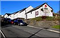
1
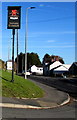
Tafarn Tanerdy name sign Carmarthen
Brains Brewery pub name sign on the corner of the A484 Tanerdy
and Penlanffos Road near this https://www.geograph.org.uk/photo/6326275 pub.
Image: © Jaggery
Taken: 18 Nov 2019
0.02 miles
2
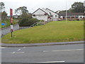
Tafarn Tanerdy, Carmarthen
Pub set back from the north side of Tanerdy (the A484), on the corner of Penlanffos Road.
Image: © Jaggery
Taken: 12 Aug 2012
0.02 miles
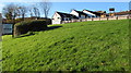
3
Glantowy bungalows, Carmarthen
Glantowy is a short cul-de-sac on the north side of the A484, here named Tanerdy.
Image: © Jaggery
Taken: 12 Aug 2012
0.02 miles
4
Clos Caebanc sign, Carmarthen
In November 2019 the BJP sign on the corner of the A484 Tanerdy and Penlanffos Road shows
CLOS CAEBANC - EXECUTIVE HOMES AND SERVICED BUILDING PLOTS FOR SALE.
Image: © Jaggery
Taken: 18 Nov 2019
0.03 miles
5
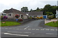
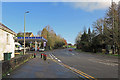
Shell Garage, Tanerdy, Carmarthen
The Shell garage at the junction of Abbey Mead and Tanerdy Road from the footpath opposite
Image: © Alan Harris
Taken: 16 Feb 2010
0.04 miles
6
Tafarn Tanerdy, Penlanffos Road, Carmarthen
A Brains Brewery pub viewed from the corner of the A484 Tanerdy.
Image: © Jaggery
Taken: 18 Nov 2019
0.04 miles
7
Pub on top of a grassy bank, Carmarthen
The pub is Tafarn Tanerdy. https://www.geograph.org.uk/photo/6326275
Image: © Jaggery
Taken: 18 Nov 2019
0.05 miles
8
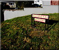
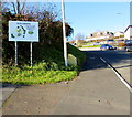
Two name signs on a grassy bank, Carmarthen
Located on the right here https://www.geograph.org.uk/photo/3082955 the signs shows that the cul-de-sac Glantowy in English is Glantywi in Welsh.
Image: © Jaggery
Taken: 18 Nov 2019
0.05 miles
9
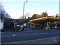
Petrol station on Tanerdy
Tanerdy - originally the A40 and Roman road to Brecon - gets its name from the tannery that was on this corner in the early 19th century.
Image: © Dylan Moore
Taken: 28 Jan 2020
0.05 miles
10
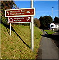
Two brown signs on a bank alongside the A484 Tanerdy, Carmarthen
Left ahead for steam railway (rheilffordd ager in Welsh) 2 miles away.
Right ahead for museum (amgueddfa in Welsh) 1 mile away.
Image: © Jaggery
Taken: 18 Nov 2019
0.06 miles