IMAGES TAKEN NEAR TO
Haulfryn, CARMARTHEN, SA31 2DS
Introduction
This page details the photographs taken nearby to Haulfryn, SA31 2DS by members of the Geograph project.
The Geograph project started in 2005 with the aim of publishing, organising and preserving representative images for every square kilometre of Great Britain, Ireland and the Isle of Man.

There are currently over 7.5m images from over14,400 individuals and you can help contribute to the project by visiting https://www.geograph.org.uk
Image Map
Images are licensed for reuse under creativecommons.org/licenses/by-sa/2.0
Notes
- Clicking on the map will re-center to the selected point.
- The higher the marker number, the further away the image location is from the centre of the postcode.
Image Listing (5 Images Found)
Images are licensed for reuse under creativecommons.org/licenses/by-sa/2.0
Image
Details
Distance
1
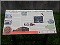
Llangunnor Trails Information Panel
Near a bus stop on Pensarn Road. The panel gives information about the village of Pensarn which grew here in the C19th and subsequent changes
Image: © Eirian Evans
Taken: 22 Sep 2022
0.22 miles
2
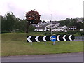
Sculpture on traffic island
Steel sculpture symbolizing the Oak Tree of Carmarthen, on the island of the bypass at Llangunnor Road.
Image: © chris whitehouse
Taken: 5 Jun 2012
0.22 miles
3
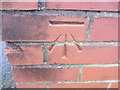
Ordnance Survey Cut Mark
This OS cut mark can be found on the Unipart building at the junction of Pensarn Road & Stephen's Way. It marks a point 6.093m above mean sea level.
Image: © Adrian Dust
Taken: 25 Jan 2014
0.22 miles
4
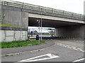
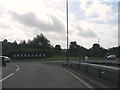
Pont Pensarn Bridge
Pensarn Road under the bridge which carries the A48. The Welsh Coast Path passes this way
Image: © Eirian Evans
Taken: 22 Sep 2022
0.24 miles