IMAGES TAKEN NEAR TO
Stephens Way, CARMARTHEN, SA31 2BG
Introduction
This page details the photographs taken nearby to Stephens Way, SA31 2BG by members of the Geograph project.
The Geograph project started in 2005 with the aim of publishing, organising and preserving representative images for every square kilometre of Great Britain, Ireland and the Isle of Man.

There are currently over 7.5m images from over14,400 individuals and you can help contribute to the project by visiting https://www.geograph.org.uk
Image Map
Images are licensed for reuse under creativecommons.org/licenses/by-sa/2.0
Notes
- Clicking on the map will re-center to the selected point.
- The higher the marker number, the further away the image location is from the centre of the postcode.
Image Listing (119 Images Found)
Images are licensed for reuse under creativecommons.org/licenses/by-sa/2.0
Image
Details
Distance
1
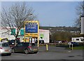
Out of Focus
Taken from the car park that used to belong to Focus (now closed). Showing the building that used to belong to Allied Carpets (now closed) and Comet (now closed). In the background are the masts on Penlan Hill (SN4121)
Image: © frank cokayne
Taken: 6 Mar 2012
0.02 miles
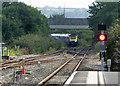
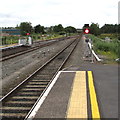
3
A view SW from Carmarthen railway station
Viewed from platform 1. All trains arrive at and leave Carmarthen station along these lines. About 600 metres away is Carmarthen Junction, where trains resume their journey, either to the west, or SE towards Llanelli and Swansea. On the right, weeds grow on the line into a disused platform. http://www.geograph.org.uk/photo/2526247
Image: © Jaggery
Taken: 30 May 2011
0.08 miles
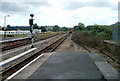
4
A view SW from platform 2, Carmarthen railway station
All trains arrive at and leave the station along these lines. Beyond the NE end of the station is a dead end. http://www.geograph.org.uk/photo/2983872 About 600 metres ahead is Carmarthen Junction, where trains resume their journey, either to the west, or SE towards Llanelli and Swansea.
The line on the left is not normally used for passenger services. Today, a Sunday, some Arriva Trains Wales units http://www.geograph.org.uk/photo/2983984 are stabled on the line, behind the camera.
Image: © Jaggery
Taken: 3 Jun 2012
0.08 miles
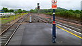
5
Railway beyond Carmarthen station
Towards Carmarthen Junction viewed from the southwest end of platform 1.
Carmarthen is a dead-end station. All trains enter towards the camera and leave away from the camera.
Image: © Jaggery
Taken: 13 Jul 2019
0.09 miles
6
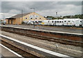
3A's Leisure, Carmarthen
Caravan dealers' premises located on the north side of Stephens Way, viewed across Carmarthen railway station. The edge of the premises borders platform 2.
Image: © Jaggery
Taken: 30 May 2011
0.09 miles
7
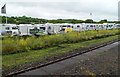
3A's Leisure, Carmarthen
The edge of a caravan and motor home dealer's premises in Stephens Way, viewed from Carmarthen railway station.
Image: © Jaggery
Taken: 3 Jun 2012
0.09 miles
8
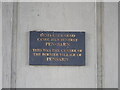
Plaque on Pensarn Bridge
The village gave way to the forward march of concrete and cars
Image: © Eirian Evans
Taken: 22 Sep 2022
0.11 miles
9
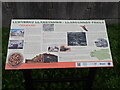
Llangunnor Trails Information Panel
Near a bus stop on Pensarn Road. The panel gives information about the village of Pensarn which grew here in the C19th and subsequent changes
Image: © Eirian Evans
Taken: 22 Sep 2022
0.11 miles
10
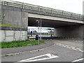
Pont Pensarn Bridge
Pensarn Road under the bridge which carries the A48. The Welsh Coast Path passes this way
Image: © Eirian Evans
Taken: 22 Sep 2022
0.12 miles