IMAGES TAKEN NEAR TO
Spilman Street, CARMARTHEN, SA31 1SR
Introduction
This page details the photographs taken nearby to Spilman Street, SA31 1SR by members of the Geograph project.
The Geograph project started in 2005 with the aim of publishing, organising and preserving representative images for every square kilometre of Great Britain, Ireland and the Isle of Man.

There are currently over 7.5m images from over14,400 individuals and you can help contribute to the project by visiting https://www.geograph.org.uk
Image Map
Images are licensed for reuse under creativecommons.org/licenses/by-sa/2.0
Notes
- Clicking on the map will re-center to the selected point.
- The higher the marker number, the further away the image location is from the centre of the postcode.
Image Listing (525 Images Found)
Images are licensed for reuse under creativecommons.org/licenses/by-sa/2.0
Image
Details
Distance
1
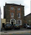
Napier House, Spilman Street, Carmarthen
A Grade II listed https://www.britishlistedbuildings.co.uk/300009599-napier-house-carmarthen#.WUDn-esrKM8 early 19th century town house, which has variously been a home, a masonic lodge, the headquarters of a sports club and the offices of a firm of chartered surveyors. Its listing was granted in 1981, and records that this is an "unusually architectural late Georgian town house" with internal and external features.
Image: © Richard Law
Taken: 30 May 2017
0.01 miles
2
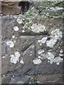
Ordnance Survey Cut Mark
This OS cut mark can be found on No13 Spillman Street which is now Llewellyn Humphreys Surveyors. It marks a point 23.582m above mean sea level.
Image: © Adrian Dust
Taken: 25 Jan 2014
0.01 miles
3
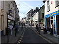
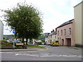
King Street Caerfyrddin/Carmarthen
Looking west from St Peter's church. King Street was the town's main commercial centre until new developments took place elsewhere. It still has many traditional-type shops, banks and the post office.
Image: © Natasha Ceridwen de Chroustchoff
Taken: 11 Aug 2007
0.02 miles
4
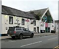
Stag & Pheasant
The dog-friendly pub describes itself as a traditional British pub. https://www.stagandpheasant.co.uk/
Image
Note: This photograph is for record purposes only. The photographer has no personal connection with the business depicted.
Image: © Gerald England
Taken: 17 Oct 2021
0.02 miles
5
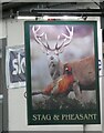
Sign of the Stag & Pheasant
Sign for the Stag & Pheasant Image
Image: © Gerald England
Taken: 17 Oct 2021
0.02 miles
6
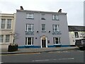
Hotel Spilman
The hotel was originally a doctor's townhouse dating from 1840. On the wall is blue plaque commemorating Elizabeth Phillips Hughes Image
Image: © Gerald England
Taken: 17 Oct 2021
0.02 miles
7
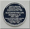
Elizabeth Phillips Hughes (1851-1925)
A blue plaque on Hotel Spilman Image reads:
CYMDEITHAS DDINESIG CAERFYRDDIN
Cartref yr arloeswraig
addysg uwch i fenywod
a sylfaenydd Neuadd Hughes,
Caergrawnt circa 1852 - 1866
ELIZABETH PHILLIPS
HUGHES LL.D.
1851-1925
Pioneer of women's higher education
and founder of Hughes Hall,
Cambridge lived here
circa 1852 - 1866
CARMARTHEN CIVIC SOCIETY
Wikipedia: https://en.wikipedia.org/wiki/Elizabeth_Phillips_Hughes
Image: © Gerald England
Taken: 17 Oct 2021
0.02 miles
9
Parade Road/Heol Y Rhodfa
Carmarthen, Wales
Image: © Jeff Gogarty
Taken: 15 May 2015
0.02 miles
10
King Morgan Chemist
People of Carmarthen owe a huge debt to the King Morgan Brothers who once owned this chemist shop. Speaking as one who sat in there parlour at three in the morning waiting for a prescription. No one turned away.
Image: © John Duckfield
Taken: 15 Sep 2009
0.03 miles