1
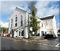
Agriculture House on John Street, Carmarthen
Image: © Ian S
Taken: 21 Jan 2015
0.01 miles
2
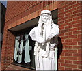
Living sculpture reaches West Wales
Outside Marchnad Caerfyrddin/Carmarthen Market on October 3rd 2006.
Image: © Natasha Ceridwen de Chroustchoff
Taken: 3 Oct 2006
0.01 miles
3
Canolfanbydgwaith / Jobcentreplus
The building on John Street occupies the site of the former Ebenezer Wesleyan Chapel.
Ebenezer Methodist Chapel was built in 1824 and altered/rebuilt in 1856, before closing in about 1920. The chapel was Simple Round-Headed in style and of the gable entry type. In 1995 the building was demolished to make way for a Job Centre. The burial ground remains to the north, with iron railings by Isaac Williams & Son and some interesting tombs. https://coflein.gov.uk/en/site/6248/
Image: © Gerald England
Taken: 20 Oct 2021
0.01 miles
4
The Coracle Tavern, John Street, Carmarthen
Image: © Ian S
Taken: 21 Jan 2015
0.02 miles
5
The Coracle Tavern, Carmarthen/Caerfyrddin
The Coracle is located in the centre of Carmarthen close to the new shopping centre.
Image: © Maigheach-gheal
Taken: 23 Sep 2010
0.02 miles
6
Sign for the Coracle Tavern
Coracles are small, keel-less boats, traditionally made as a basketwork frame, covered with an animal hide. In Wales they are now skinned with calico which is waterproofed using a bitumastic paint.
Image: © Maigheach-gheal
Taken: 23 Sep 2010
0.02 miles
7
The Coracle Tavern, John Street, Carmarthen
Image: © Ian S
Taken: 21 Jan 2015
0.03 miles
8
The Coracle Tavern
Image: © Alex McGregor
Taken: 24 Sep 2019
0.03 miles
9
Site of Ebenezer Methodist Chapel, John Street, Carmarthen
Ebenezer Welsh Wesleyan Methodist Chapel was built in 1824 and re-built in 1856, closing in 1920. The building, which became known as Wesley House, was occupied by the Carmarthen Farmers’ Co-operative Society for many years. It was demolished in 1995 and replaced by the Job Centre.
The building bore OSBM flush bracket G3220:
Height (1954): 15.7306m OD (Newlyn). Mark verified by the Ordnance Survey in 1976. Description: FL BR G3220 WESLEY HO NW ANG NW FACE. 0.5m above ground. 1st Order BM. SN 4117 2025
The bracket was used on the Carmarthen to Haverford West line (G075) of the Third Geodetic Levelling of England & Wales in 1954. It was also included on the Haverford West, via Tenby to Carmarthen line (G163) in 1962. Description: W angle of Carmarthen Farmer's Coop Society Building, E side of John Street. Abstract G 64: http://discovery.nationalarchives.gov.uk/SearchUI/details?Uri=C11264472 [OS 54/753]
Image: © N Scott
Taken: 31 May 2023
0.04 miles
10
Stalls in the new market
The new covered market has a rather clinical aspect and lacks the character and spaciousness of the old one. The ceiling is low and there is a uniformity about the stalls which means it is a much less interesting place to shop. Although many of the traders are the same, a number of the more unusual ones seem to have gone.
Image: © Natasha Ceridwen de Chroustchoff
Taken: 22 Sep 2010
0.04 miles


