IMAGES TAKEN NEAR TO
Rhodfa Glyndwr, CARMARTHEN, SA31 1QF
Introduction
This page details the photographs taken nearby to Rhodfa Glyndwr, SA31 1QF by members of the Geograph project.
The Geograph project started in 2005 with the aim of publishing, organising and preserving representative images for every square kilometre of Great Britain, Ireland and the Isle of Man.

There are currently over 7.5m images from over14,400 individuals and you can help contribute to the project by visiting https://www.geograph.org.uk
Image Map
Images are licensed for reuse under creativecommons.org/licenses/by-sa/2.0
Notes
- Clicking on the map will re-center to the selected point.
- The higher the marker number, the further away the image location is from the centre of the postcode.
Image Listing (7 Images Found)
Images are licensed for reuse under creativecommons.org/licenses/by-sa/2.0
Image
Details
Distance
1
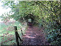
Llwybr i Gronfeydd Cwmoernant / Path to the Cwmoernant Reservoirs
Llwybr cyhoeddus yn arwain at Gronfeydd Cwmoernant.
A public footpath heading towards the Cwmoernant Reservoirs (trans. valley of the cold stream).
Image: © Alan Richards
Taken: 9 Oct 2019
0.13 miles
2
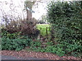
G?t fochyn yng Nghwmoerant / Kissing gate in Cwmoernant
Llwybr cyhoeddus yn gadael yr heol yng Nghwmoernant.
A public footpath exiting the road at Cwmoernant (trans. valley of the cold stream).
Image: © Alan Richards
Taken: 9 Oct 2019
0.15 miles
3
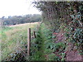
Llwybr i Gwmoernant / Path to Cwmoernant
Llwybr cyhoeddus yn arwain at dreflan Cwmoernant.
A public footpath approaching the hamlet of Cwmoernant (trans. valley of the cold stream).
Image: © Alan Richards
Taken: 9 Oct 2019
0.16 miles
4
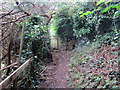
Llwybr i Gwmoernant / Path to Cwmoernant
Llwybr cyhoeddus yn arwain at dreflan Cwmoernant.
A public footpath heading towards the hamlet of Cwmoernant (trans. valley of the cold stream).
Image: © Alan Richards
Taken: 9 Oct 2019
0.16 miles
5
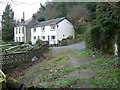
Cwm-Oernant
Looking from the start of uphill stretch of public footpath through woods.
Image: © frank cokayne
Taken: 28 Feb 2012
0.19 miles
6
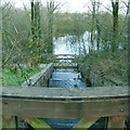
Carmarthen Reservoirs
Looking down from a bridge over the dam of the upper reservoir down the stepped waterfall to the bridge at the back of the lower reservoir.
Image: © Nigel Davies
Taken: 3 Apr 2006
0.21 miles
7
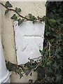
Ordnance Survey Cut Mark
This OS cut mark can be found on Penrhos House, Springfield Road. It marks a point 51.624m above mean sea level.
Image: © Adrian Dust
Taken: 1 Mar 2014
0.24 miles