IMAGES TAKEN NEAR TO
Little Water Street, CARMARTHEN, SA31 1HB
Introduction
This page details the photographs taken nearby to Little Water Street, SA31 1HB by members of the Geograph project.
The Geograph project started in 2005 with the aim of publishing, organising and preserving representative images for every square kilometre of Great Britain, Ireland and the Isle of Man.

There are currently over 7.5m images from over14,400 individuals and you can help contribute to the project by visiting https://www.geograph.org.uk
Image Map (Loading...)


Getting Data...Please wait
Leaflet Map data © OpenStreetMap
Images are licensed for reuse under creativecommons.org/licenses/by-sa/2.0
Notes
- Clicking on the map will re-center to the selected point.
- The higher the marker number, the further away the image location is from the centre of the postcode.
Image Listing (426 Images Found)
Images are licensed for reuse under creativecommons.org/licenses/by-sa/2.0
Image
Details
Distance
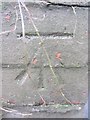
2
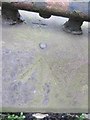
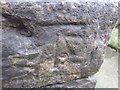
Ordnance Survey Rivet
This OS Rivet can be found on the wall with railings to the NW angle of No54 Little Water Street. It marks a point 18.810m above mean sea level.
Image: © Adrian Dust
Taken: 1 Mar 2014
0.03 miles
3
Location of OS Pivot - Carmarthen, Notts Square Monument
Image: © thejackrustles
Taken: 9 Oct 2022
0.03 miles
4
Entrance to Parc Myrddin, Carmarthen
Viewed from near the meeting point of Francis Terrace and Richmond Terrace.
A turquoise plaque http://www.geograph.org.uk/photo/2435182 records that the Queen Elizabeth Grammar School for Boys, founded in 1576, was at this site from 1884 to 1978.
Image: © Jaggery
Taken: 30 May 2011
0.04 miles
5
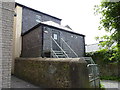
Ordnance Survey Cut Mark
This OS cut mark can be found on the wall of No44 Richmond Terrace. It marks a point 21.164m above mean sea level.
Image: © Adrian Dust
Taken: 25 Jan 2014
0.05 miles
6
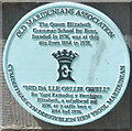
Plaque marking site of Queen Elizabeth Grammar School for Boys, Carmarthen
The Old Maridunians Association plaque is at the entrance http://www.geograph.org.uk/photo/2435179 to Parc Myrddin.
Image: © Jaggery
Taken: 30 May 2011
0.06 miles
7
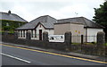
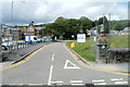
St John Ambulance HQ, Carmarthen
Viewed across Barn Road.
Image: © Jaggery
Taken: 12 Aug 2012
0.08 miles
8
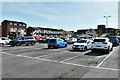
Back of building next to King Street Car Park
One of the less scenic parts of Carmarthen.
This is the back of the building in Image
Image: © Jeff Gogarty
Taken: 15 May 2015
0.09 miles
9
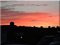
Machlud dros Meddygfa San Pedr, Caerfyrddin / Sunset over St Peter's Surgery, Carmarthen
Image: © David Jones
Taken: 30 Aug 2013
0.10 miles
10
Ordnance Survey Cut mark
This OS cut mark can be found at the junction of Waterloo Terrace & Barnsfield Terrace. It marks a point 18.977m above mean sea level.
Image: © Adrian Dust
Taken: 25 Jan 2014
0.10 miles