1
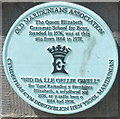
Plaque marking site of Queen Elizabeth Grammar School for Boys, Carmarthen
The Old Maridunians Association plaque is at the entrance http://www.geograph.org.uk/photo/2435179 to Parc Myrddin.
Image: © Jaggery
Taken: 30 May 2011
0.03 miles
2
Ordnance Survey Rivet
This OS Rivet can be found on the wall with railings to the NW angle of No54 Little Water Street. It marks a point 18.810m above mean sea level.
Image: © Adrian Dust
Taken: 1 Mar 2014
0.04 miles
3
Machlud dros Meddygfa San Pedr, Caerfyrddin / Sunset over St Peter's Surgery, Carmarthen
Image: © David Jones
Taken: 30 Aug 2013
0.06 miles
4
Ordnance Survey Cut Mark
This OS cut mark can be found on the wall of No44 Richmond Terrace. It marks a point 21.164m above mean sea level.
Image: © Adrian Dust
Taken: 25 Jan 2014
0.06 miles
5
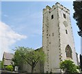
St Peter's Church, Carmarthen
This church is at the end of King Street, near the library. The unfinished look of the grey-white rendering on the clock tower is allegedly a restoration of the church's original condition.
Image: © Nigel Davies
Taken: 28 Jun 2005
0.06 miles
6
Back of building next to King Street Car Park
One of the less scenic parts of Carmarthen.
This is the back of the building in
Image
Image: © Jeff Gogarty
Taken: 15 May 2015
0.07 miles
7
King's Street Car Park, Carmarthen
Radio masts on Penlan Hill can be seen in the distance
Image: © Jeff Gogarty
Taken: 15 May 2015
0.07 miles
8
Location of OS Pivot - Carmarthen, Notts Square Monument
Image: © thejackrustles
Taken: 9 Oct 2022
0.07 miles
9
Ciosg Coch Telegyfathrebu Phrydeinig - - - British Telecommunication's red kiosk
Telegyfathrebu tynnwyd yn y maes parcio; oddi ar Stryd Sant Pedr
- - - - -
Telecommunications taken at the car park just off Saint Peter's street
Image: © G Williams
Taken: 27 Nov 2008
0.07 miles
10
Entrance to Parc Myrddin, Carmarthen
Viewed from near the meeting point of Francis Terrace and Richmond Terrace.
A turquoise plaque http://www.geograph.org.uk/photo/2435182 records that the Queen Elizabeth Grammar School for Boys, founded in 1576, was at this site from 1884 to 1978.
Image: © Jaggery
Taken: 30 May 2011
0.08 miles


