IMAGES TAKEN NEAR TO
Broadacre, SWANSEA, SA2 7RU
Introduction
This page details the photographs taken nearby to Broadacre, SA2 7RU by members of the Geograph project.
The Geograph project started in 2005 with the aim of publishing, organising and preserving representative images for every square kilometre of Great Britain, Ireland and the Isle of Man.

There are currently over 7.5m images from over14,400 individuals and you can help contribute to the project by visiting https://www.geograph.org.uk
Image Map (9 Images)


Getting Data...Please wait
Leaflet Map data © OpenStreetMap
Images are licensed for reuse under creativecommons.org/licenses/by-sa/2.0
Notes
- Clicking on the map will re-center to the selected point.
- The higher the marker number, the further away the image location is from the centre of the postcode.
Image Listing (9 Images Found)
Images are licensed for reuse under creativecommons.org/licenses/by-sa/2.0
Image
Details
Distance
1
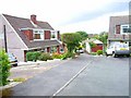
Y Glyn, Dunvant
1960s Wimpey semi-detached dormer bungalows. The far house on the left (number 7) is the first house I owned back in 1966.
Image: © Oliver Dixon
Taken: 21 Jun 2006
0.07 miles
2
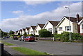
Broadmead, Dunvant
A lot of the dwellings on this road have beautiful views over open countryside.
Image: © john bristow
Taken: 8 Jun 2012
0.14 miles
3
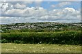
Dunvant and Killay
Dunvant and Killay, seen from Upper Killay
Image: © john bristow
Taken: 5 Jun 2020
0.16 miles
4
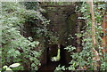
An impressive stone culvert
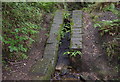
This culvert, presumably built as part of the railway, carries the Clyne River under the Clyne Trail.
Image: © john bristow
Taken: 8 Aug 2012
0.18 miles
5
Llwybr Beicio Dyfnant/ Dunvant Cycle Path
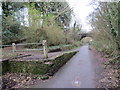
Llwybr troed yn gadael y ffordd seiclo ger hen Orsaf Reilfordd y Dyfnant. Caewyd y lein yn 1964 gan fwyell Beeching.
A footpath leaving the cycle path near Dunvant < Dyfnant (trans deep valley) near the former Dunvant Railway Station. The line closed in 1964 by the now infamous Beeching Axe.
Image: © Alan Richards
Taken: 5 Jan 2015
0.23 miles
6
Derlwyn, Dunvant
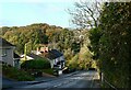
Access to a large housing estate.
Image: © Bill Boaden
Taken: 6 Apr 2016
0.24 miles
7
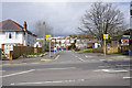
Dunvant Road near the former railway bridge
Image: © john bristow
Taken: 26 Oct 2020
0.24 miles
8
Water channel on the Clyne Trail
This structure must have been built as part of the original railway as it is constructed in engineering brick.
Image: © john bristow
Taken: 8 Aug 2012
0.24 miles
9
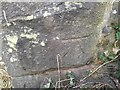
Ordnance Survey Cut Mark
This OS cut mark can be found on the SE buttress of the railway bridge. It marks a point 175.4ft above mean sea level.
Image: © Adrian Dust
Taken: 15 Feb 2023
0.25 miles