IMAGES TAKEN NEAR TO
Llethryd, SWANSEA, SA2 7LH
Introduction
This page details the photographs taken nearby to SA2 7LH by members of the Geograph project.
The Geograph project started in 2005 with the aim of publishing, organising and preserving representative images for every square kilometre of Great Britain, Ireland and the Isle of Man.

There are currently over 7.5m images from over14,400 individuals and you can help contribute to the project by visiting https://www.geograph.org.uk
Image Map
Images are licensed for reuse under creativecommons.org/licenses/by-sa/2.0
Notes
- Clicking on the map will re-center to the selected point.
- The higher the marker number, the further away the image location is from the centre of the postcode.
Image Listing (14 Images Found)
Images are licensed for reuse under creativecommons.org/licenses/by-sa/2.0
Image
Details
Distance
1
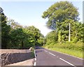
Approach to Llethrid Bridge
The wall is the boundary of a garden, and continues as the bridge parapet; the opposite parapet is visible in the hedge
Image: © David Smith
Taken: 3 Jun 2018
0.03 miles
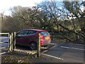
2
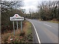
Llethryd
Y B4271 yn cyrraedd pentref bach Llethryd. Enwir y pentref ar ol Nant Llethrid gerllaw sy'n golygu 'disglair /llachar'.
The B4271 arriving at the tiny hamlet of Llethryd. The village is named after the nearby Llethrid stream which means 'shining / bright'.
Image: © Alan Richards
Taken: 14 Feb 2015
0.04 miles
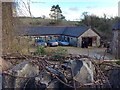
3
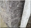
Ordnance Survey Cut Mark
This OS cut mark can be found on the roadside barn at Llethryd Farm. It marks a point 46.723m above mean sea level.
Image: © Adrian Dust
Taken: 14 Feb 2022
0.07 miles
4
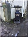
Milk Churn
Milk churn at Llethryd Farm. Note that the stand is a weighing scale.
Image: © Alan Hughes
Taken: 28 Jan 2017
0.07 miles
6
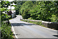
Ilston Community: the B4271 at Llethrid Bridge
Looking south west
Image: © Martin Bodman
Taken: 10 Jun 2006
0.09 miles
7
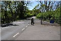
Cattle grid on the B4271
Cattle grid on the B4271 near Llethrid Bridge.
Image: © Philip Halling
Taken: 17 May 2014
0.12 miles
8
Cattle Grid
Car crossing cattle grid on Pengwern Common.
Image: © Alan Hughes
Taken: 28 Jan 2017
0.12 miles
9
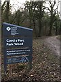
Woodland Sign
Sign alongside woodland path at Coed y Parc.
Image: © Alan Hughes
Taken: 28 Jan 2017
0.14 miles
10
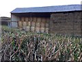
Hay Bales
Round and square bales of hay stored in barn at Llethryd.
Image: © Alan Hughes
Taken: 28 Jan 2017
0.14 miles