IMAGES TAKEN NEAR TO
Pinewood Road, SWANSEA, SA2 0LT
Introduction
This page details the photographs taken nearby to Pinewood Road, SA2 0LT by members of the Geograph project.
The Geograph project started in 2005 with the aim of publishing, organising and preserving representative images for every square kilometre of Great Britain, Ireland and the Isle of Man.

There are currently over 7.5m images from over14,400 individuals and you can help contribute to the project by visiting https://www.geograph.org.uk
Image Map (Loading...)


Getting Data...Please wait
Leaflet Map data © OpenStreetMap
Images are licensed for reuse under creativecommons.org/licenses/by-sa/2.0
Notes
- Clicking on the map will re-center to the selected point.
- The higher the marker number, the further away the image location is from the centre of the postcode.
Image Listing (27 Images Found)
Images are licensed for reuse under creativecommons.org/licenses/by-sa/2.0
Image
Details
Distance
1
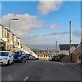
Hawthorne Avenue
Looking down over Uplands towards the tower of the Guildhall. Smoke billowing from the Port Talbot Steelworks is visible in the distance.
Image: © Z Pryce
Taken: 4 Feb 2022
0.06 miles
2
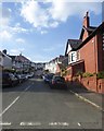
Le-Breos Avenue, Uplands
One of many residential roads leading from Sketty Road
Image: © David Smith
Taken: 3 Jun 2018
0.09 miles
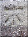
3

Ordnance Survey Cut Mark
This OS cut mark can be found on the wall between Nos. 80 & 82 Gower Road. It marks a point 50.856m above mean sea level.
Image: © Adrian Dust
Taken: 5 Dec 2013
0.09 miles
5
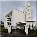
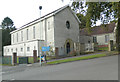
St Benedict's Catholic Church, Sketty
The entrance is on Llythrid Avenue, just off Sketty Road in the far eastern part of Sketty.
Image: © Z Pryce
Taken: 4 Oct 2021
0.12 miles
6
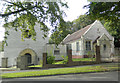
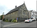
Capel y Trinity, Swansea
Eglwys Bresbyteraidd Cymru / Presbyterian Church of Wales
Image: © John Lord
Taken: 6 Oct 2017
0.12 miles
9
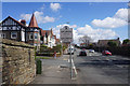
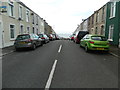
Sketty Road entering Uplands
The sign states that this was the birthplace of Dylan Thomas. The area is very proud of its connection with the poet, and this is not the only reference you will find.
Image: © Bill Boaden
Taken: 5 Apr 2016
0.15 miles
10
Ordnance Survey Cut Mark
This OS cut mark can be found on the wall on Sketty Road at the junction with Hawthorne Avenue. It marks a point 49.786m above mean sea level.
Image: © Adrian Dust
Taken: 5 Dec 2013
0.16 miles