IMAGES TAKEN NEAR TO
Penbryn Terrace, SWANSEA, SA2 0DA
Introduction
This page details the photographs taken nearby to Penbryn Terrace, SA2 0DA by members of the Geograph project.
The Geograph project started in 2005 with the aim of publishing, organising and preserving representative images for every square kilometre of Great Britain, Ireland and the Isle of Man.

There are currently over 7.5m images from over14,400 individuals and you can help contribute to the project by visiting https://www.geograph.org.uk
Image Map (Loading...)


Getting Data...Please wait
Leaflet Map data © OpenStreetMap
Images are licensed for reuse under creativecommons.org/licenses/by-sa/2.0
Notes
- Clicking on the map will re-center to the selected point.
- The higher the marker number, the further away the image location is from the centre of the postcode.
Image Listing (44 Images Found)
Images are licensed for reuse under creativecommons.org/licenses/by-sa/2.0
Image
Details
Distance
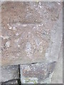
1
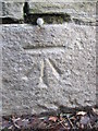
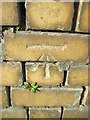
Ordnance Survey Cut Mark
This OS cut mark can be found on the roadside wall below NO21 Brynmill Lane. It marks a point 16.767m above mean sea level.
Image: © Adrian Dust
Taken: 28 Jan 2015
0.07 miles
2
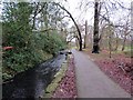
Nant Bryn Mill Stream
Nant Brynmill ym Mharc Singlton yn llifo tuag at Draeth Abertawe gerllaw. Yn ystod y Canol Oesoedd gelwid y ffrwd yn ogystal yn Saint David's Ditch a hwn oedd yn pennu hen ffin orllewinol Bwrdeistref Abertawe.
Brynmill Stream in Singleton Park flowing towards nearby Swansea Bay. During the Middle Ages this watercourse was also known as Saint David's Ditch and it also served as the western boundary of the medieval borough of Swansea.
Image: © Alan Richards
Taken: 13 Jan 2015
0.08 miles
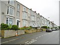
4
Brynmill Coffee House
Half way down Brynmill Terrace.
Image: © Eirian Evans
Taken: 7 May 2019
0.09 miles
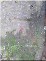
5
Ordnance Survey Cut Mark
This OS cut mark can be found on the wall of No106 Bryn Road. It marks a point 17.160m above mean sea level.
Image: © Adrian Dust
Taken: 28 Jan 2015
0.09 miles
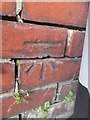
6
Ordnance Survey Cut Mark
This OS cut mark can be found on the gatepost of the entrance to Singleton Park on Brynmill Lane. It marks a point 18.373m above mean sea level.
Image: © Adrian Dust
Taken: 28 Jan 2015
0.10 miles
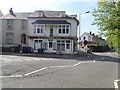
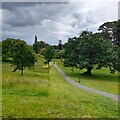
7
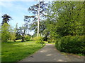
Singleton Park
Eastern entrance to the park, half way down Brynmill Terrace. The park was originally part of the Vivian family estate, which was purchased by Swansea County Borough Council in 1919 for use as a public park
Image: © Eirian Evans
Taken: 7 May 2019
0.11 miles
8
Ordnance Survey Cut Mark
This OS cut mark can be found on the wall of No68 Alexandria Terrace. It marks a point 28.889m above mean sea level.
Image: © Adrian Dust
Taken: 28 Jan 2015
0.12 miles
9
Ordnance Survey Cut Mark
This OS cut mark can be found on the wall fronting No57 Bryn Road. It marks a point 17.087m above mean sea level.
Image: © Adrian Dust
Taken: 28 Jan 2015
0.13 miles
10
Path through Singleton Park
Linking Brynmill to the university campus. New paths have recently been cut through the grass to facilitate social distancing as the park has seen increased use during the pandemic.
Image: © Z Pryce
Taken: 18 Jun 2021
0.13 miles