IMAGES TAKEN NEAR TO
Babel, LLANDOVERY, SA20 0SB
Introduction
This page details the photographs taken nearby to SA20 0SB by members of the Geograph project.
The Geograph project started in 2005 with the aim of publishing, organising and preserving representative images for every square kilometre of Great Britain, Ireland and the Isle of Man.

There are currently over 7.5m images from over14,400 individuals and you can help contribute to the project by visiting https://www.geograph.org.uk
Image Map (Loading...)


Getting Data...Please wait
Leaflet Map data © OpenStreetMap
Images are licensed for reuse under creativecommons.org/licenses/by-sa/2.0
Notes
- Clicking on the map will re-center to the selected point.
- The higher the marker number, the further away the image location is from the centre of the postcode.
Image Listing (3 Images Found)
Images are licensed for reuse under creativecommons.org/licenses/by-sa/2.0
Image
Details
Distance
1
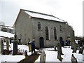
Capel Cefnarthen
Cefnarthen, addoldy'r Annibynwyr ac adeiladwyd y capel cyntaf yn 1689. Codwyd yr adeilad presennol yn 1854 a hwn yw'r trydydd ty cwrdd a codwyd ar y safle.
Cefnarthen, the meeting house of the Independents and the first chapel was erected in 1689. The present building, built in 1854, is the third chapel to be erected on the site.
Image: © Alan Richards
Taken: 5 Mar 2006
0.13 miles
2
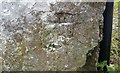
Ordnance Survey Cut Mark
This badly damaged OS cut mark can be found on a roadside barn at Pen-y-Rhiw Farm. It marked a point 688.8ft above mean sea level.
Image: © Adrian Dust
Taken: 7 Apr 2019
0.20 miles
3
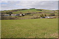
Farmland around Babel
View across farmland at Babel with farms of Glyntywarch and Penrhiw in the middle distance.
Image: © Philip Halling
Taken: 4 May 2013
0.24 miles