IMAGES TAKEN NEAR TO
Halfway, LLANDOVERY, SA20 0RY
Introduction
This page details the photographs taken nearby to SA20 0RY by members of the Geograph project.
The Geograph project started in 2005 with the aim of publishing, organising and preserving representative images for every square kilometre of Great Britain, Ireland and the Isle of Man.

There are currently over 7.5m images from over14,400 individuals and you can help contribute to the project by visiting https://www.geograph.org.uk
Image Map
Images are licensed for reuse under creativecommons.org/licenses/by-sa/2.0
Notes
- Clicking on the map will re-center to the selected point.
- The higher the marker number, the further away the image location is from the centre of the postcode.
Image Listing (9 Images Found)
Images are licensed for reuse under creativecommons.org/licenses/by-sa/2.0
Image
Details
Distance
1
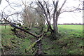
Hen heol las esgeulusedig / Old neglected green road
Hen heol las esgeulusedig uwchben Ffarm Troed y Rhiw.
A neglected old green road above Troed y Rhiw Farm (trans. foot of the hill).
Image: © Alan Richards
Taken: 4 Mar 2022
0.06 miles
2
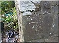
Ordnance Survey Cut Mark
This OS cut mark can be found on the north angle of the old school building. It marks a point 417.4ft above mean sea level.
Image: © Adrian Dust
Taken: 7 Apr 2019
0.13 miles
3
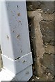
Ordnance Survey Flush Bracket (935)
This OS Flush Bracket can be found on the NE face of the old school building. It marks a point 127.473m above mean sea level.
Image: © Adrian Dust
Taken: 7 Apr 2019
0.14 miles
5
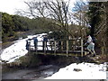
Croesi Afon Gwydderig / Crossing Afon Gwydderig
Cerddwyr yn croesi pompren sy'n rhychwantu Afon Gwydderig.
Walkers crossing a footbridge spanning the Afon Gwydderig.
Image: © Alan Richards
Taken: 5 Mar 2006
0.18 miles
6
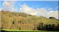
Afon Gwydderig valley
Looking across the valley from the A40 to a mix of woods and pasture.
Image: © Derek Harper
Taken: 2 Jan 2015
0.21 miles
7
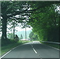
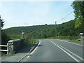
A40 Road Scene
Down a drop to the right of the road, and running parallel to it is the Afon Gwydderig.
Image: © Bonelli
Taken: Unknown
0.21 miles
8
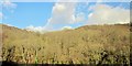
Woods in the Afon Gwydderig valley
Looking across the valley from the A40 to Allt Pen-twyn. A sloping meadow can be detected beyond the tall trees left of centre; it slopes down the valley side below the farm at Cefnpwllhen.
Image: © Derek Harper
Taken: 2 Jan 2015
0.21 miles
9
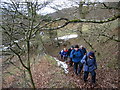
Llwybr Cefnpwllhen / Cefnpwllhen Path
Cerddwyr yn dringo llwybr tuag at Gefnpwllhen.
Walkers ascending a path towards Cefnpwllhen (trans. old pool/pit ridge).
Image: © Alan Richards
Taken: 5 Mar 2006
0.23 miles