IMAGES TAKEN NEAR TO
Rhandirmwyn, LLANDOVERY, SA20 0PH
Introduction
This page details the photographs taken nearby to SA20 0PH by members of the Geograph project.
The Geograph project started in 2005 with the aim of publishing, organising and preserving representative images for every square kilometre of Great Britain, Ireland and the Isle of Man.

There are currently over 7.5m images from over14,400 individuals and you can help contribute to the project by visiting https://www.geograph.org.uk
Image Map
Images are licensed for reuse under creativecommons.org/licenses/by-sa/2.0
Notes
- Clicking on the map will re-center to the selected point.
- The higher the marker number, the further away the image location is from the centre of the postcode.
Image Listing (22 Images Found)
Images are licensed for reuse under creativecommons.org/licenses/by-sa/2.0
Image
Details
Distance
1
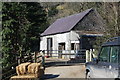
Outbuilding, Gallt-y-Bere Farm
Stone building near the farm entrance above the Afon Tywi.
Image: © M J Roscoe
Taken: 25 Feb 2018
0.01 miles
2
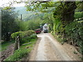
The entrance to Gallt-y-bere Farm
Two 4x4's, a tipper-truck and a horse transport crowd the entrance drive to the farmyard.
Image: © Jeremy Bolwell
Taken: 26 Apr 2011
0.02 miles
3
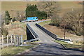
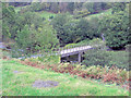
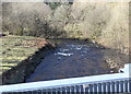
Bridge over Afon Tywi, Galt-y-Bere
The horse box and Range Rover Image are in the next grid square.
Image: © M J Roscoe
Taken: 25 Feb 2018
0.04 miles
4
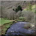
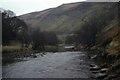
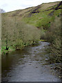
Afon Tywi north of Rhandirmwyn, Carmarthenshire
Looking east from the bridge by Gallt-y-bere farm, downstream towards Rhandirmwyn.
Information from The Carmarthenshire Rivers Trust www.carmarthenshire.org:
The source of the 75 mile long Afon Tywi lies in the Cambrian Mountains of Mid Wales, within 15 miles of the sources of the Severn and Wye, and the smaller Cardigan Bay rivers Teifi, Rheidol and Ystwyth. The upper catchment comprises afforested undulating moorland. The Tywi Fach rises at an elevation of some 1400 feet above sea level, while the Tywi Fechan rises nearby at 1600 feet.
Just 6 miles downstream, the river flows into the 4 mile long Eastern arm of Llyn Brianne reservoir, while the Afon Camddwr flows into the 3 mile Western arm. A continual release of water from the flow-regulating reservoir marks the start of the main river. The Towy falls quite steeply for 10 miles before flowing out onto the flood plain near Llandovery.
The river then meanders its way along and across the 1 mile wide, virtually flat plain for 30 miles down to Carmarthen and the 12 mile long estuary. With numerous tributaries, the average river flow increases from 157 million gallons per day (mgd) at Llandovery, to 400 mgd at Llandeilo and 855 mgd at Carmarthen (total catchment 515 sq. miles).
The main tributary is the 33 mile long Cothi. With a catchment of 116 sq. miles, the Cothi has an average flow of 120 mgd at its confluence with the Towy. Other significant tributaries include the 7 mile Doethie (20 sq. miles, 35 mgd); 13 mile Bran (50 sq. miles, 71 mgd); 10 mile Sawdde (32 sq. miles, 70 mgd), and 16 mile Gwili (57 sq. miles, 95 mgd).
Image: © Roger D Kidd
Taken: 2 Apr 2011
0.04 miles
5
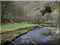
Towy to the Gwenffrwd - Ystradffin, Carmarthenshire
At one time the YHA (Youth Hostels Association) England and Wales map looked like a dose of measles with red triangles scattered liberally over it. This photo returns me to April 1982 when I spent a couple of nights at the former hostel of Bryn-poeth Uchaf Image to the east of Rhandirmwyn Image This photo was taken from the bridge over the River Towy/Tywi immediately south of Gallt-y-Bere looking westwards as it wends it way to its meeting with the River Gwenffrwd. Time photo taken not available.
Image]
Image]
Image]
Image]
Image]
Image]
Image: © Martin Richard Phelan
Taken: Unknown
0.05 miles
6
Afon Tywi north of Rhandirmwyn, Carmarthenshire
Looking east from the bridge by Gallt-y-bere farm, downstream towards Rhandirmwyn.
Information from The Carmarthenshire Rivers Trust www.carmarthenshire.org:
The source of the 75 mile long Afon Tywi lies in the Cambrian Mountains of Mid Wales, within 15 miles of the sources of the Severn and Wye, and the smaller Cardigan Bay rivers Teifi, Rheidol and Ystwyth. The upper catchment comprises of afforested undulating moorland. The Tywi Fach rises at an elevation of some 1400 feet above sea level, while the Tywi Fechan rises nearby at 1600 feet.
Just 6 miles downstream, the river flows into the 4 mile long Eastern arm of Llyn Brianne reservoir, while the Afon Camddwr flows into the 3 mile Western arm. A continual release of water from the flow-regulating reservoir marks the start of the main river. The Towy falls quite steeply for 10 miles before flowing out onto the flood plain near Llandovery.
The river then meanders its way along and across the 1 mile wide, virtually flat plain for 30 miles down to Carmarthen and the 12 mile long estuary. With numerous tributaries, the average river flow increases from 157 million gallons per day (mgd) at Llandovery, to 400 mgd at Llandeilo and 855 mgd at Carmarthen (total catchment 515 sq. miles).
The main tributary is the 33 mile long Cothi. With a catchment of 116 sq. miles, the Cothi has an average flow of 120 mgd at its confluence with the Towy. Other significant tributaries include the 7 mile Doethie (20 sq. miles, 35 mgd); 13 mile Bran (50 sq. miles, 71 mgd); 10 mile Sawdde (32 sq. miles, 70 mgd), and 16 mile Gwili (57 sq. miles, 95 mgd).
Image: © Roger D Kidd
Taken: 2 Apr 2011
0.05 miles
7
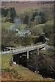
Bridge over Afon Twyi
Bridge over Afon Twyi with Gallt-y-bere on the far side which is in the next grid square.
Image: © Philip Halling
Taken: 21 Mar 2009
0.05 miles
9
Afon Twyi, Gallt-y-Bere
Looking downstream from the road bridge Image
Image: © M J Roscoe
Taken: 25 Feb 2018
0.06 miles
10
Afon Tywi north of Rhandirmwyn, Carmarthenshire
The valley is deep and meandering between Rhandirmwyn and Llyn Brianne.
Information from The Carmarthenshire Rivers Trust www.carmarthenshire.org:
The source of the 75 mile long Afon Tywi lies in the Cambrian Mountains of Mid Wales, within 15 miles of the sources of the Severn and Wye, and the smaller Cardigan Bay rivers Teifi, Rheidol and Ystwyth. The upper catchment comprises of afforested undulating moorland. The Tywi Fach rises at an elevation of some 1400 feet above sea level, while the Tywi Fechan rises nearby at 1600 feet.
Just 6 miles downstream, the river flows into the 4 mile long Eastern arm of Llyn Brianne reservoir, while the Afon Camddwr flows into the 3 mile Western arm. A continual release of water from the flow-regulating reservoir marks the start of the main river. The Towy falls quite steeply for 10 miles before flowing out onto the flood plain near Llandovery.
The river then meanders its way along and across the 1 mile wide, virtually flat plain for 30 miles down to Carmarthen and the 12 mile long estuary. With numerous tributaries, the average river flow increases from 157 million gallons per day (mgd) at Llandovery, to 400 mgd at Llandeilo and 855 mgd at Carmarthen (total catchment 515 sq. miles).
The main tributary is the 33 mile long Cothi. With a catchment of 116 sq. miles, the Cothi has an average flow of 120 mgd at its confluence with the Towy. Other significant tributaries include the 7 mile Doethie (20 sq. miles, 35 mgd); 13 mile Bran (50 sq. miles, 71 mgd); 10 mile Sawdde (32 sq. miles, 70 mgd), and 16 mile Gwili (57 sq. miles, 95 mgd).
Image: © Roger D Kidd
Taken: 2 Apr 2011
0.10 miles