IMAGES TAKEN NEAR TO
Myddfai, LLANDOVERY, SA20 0HZ
Introduction
This page details the photographs taken nearby to SA20 0HZ by members of the Geograph project.
The Geograph project started in 2005 with the aim of publishing, organising and preserving representative images for every square kilometre of Great Britain, Ireland and the Isle of Man.

There are currently over 7.5m images from over14,400 individuals and you can help contribute to the project by visiting https://www.geograph.org.uk
Image Map
Images are licensed for reuse under creativecommons.org/licenses/by-sa/2.0
Notes
- Clicking on the map will re-center to the selected point.
- The higher the marker number, the further away the image location is from the centre of the postcode.
Image Listing (6 Images Found)
Images are licensed for reuse under creativecommons.org/licenses/by-sa/2.0
Image
Details
Distance
1
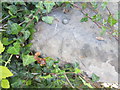
Ordnance Survey Rivet
This OS rivet can be found to the NE of the road on an old milk stand. It marks a point 136.627m above mean sea level.
Image: © Adrian Dust
Taken: 31 Aug 2014
0.03 miles
2
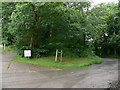
Myrtle Hill, Myddfai
Black sign reads Gollen wen. photo taken from OS 1:25000 spot height marked as 159m, the highest point of the road over Myrtle hill.
Image: © Bonelli
Taken: Unknown
0.13 miles
3
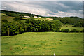
Looking into the valley of Afon Ydw, Myddfai
Image: © Humphrey Bolton
Taken: 4 Jul 1999
0.17 miles
4
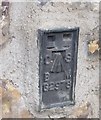
Ordnance Survey Flush Bracket (G2978)
This OS Flush Bracket can be found on the house north side of the road. It marks a point 150.957m above mean sea level.
Image: © Adrian Dust
Taken: 28 Jun 2020
0.20 miles
5
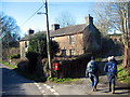
Myrtle Hill
Cerddwyr yn dilyn llwybr cyhoeddus wrth anhedd-dy o'r enw Myrtle Hill.
Walkers following a public footpath at a property known as Myrtle Hill.
Image: © Alan Richards
Taken: 3 Feb 2007
0.21 miles
6

Pombren Afon Ydw / Afon Ydw footbridge
Pombren yn rhychwantu Afon Ydw.
A footbridge spanning Afon Ydw.
Image: © Alan Richards
Taken: 21 Jan 2022
0.24 miles