IMAGES TAKEN NEAR TO
LLANGADOG, SA19 9HS
Introduction
This page details the photographs taken nearby to SA19 9HS by members of the Geograph project.
The Geograph project started in 2005 with the aim of publishing, organising and preserving representative images for every square kilometre of Great Britain, Ireland and the Isle of Man.

There are currently over 7.5m images from over14,400 individuals and you can help contribute to the project by visiting https://www.geograph.org.uk
Image Map
Images are licensed for reuse under creativecommons.org/licenses/by-sa/2.0
Notes
- Clicking on the map will re-center to the selected point.
- The higher the marker number, the further away the image location is from the centre of the postcode.
Image Listing (10 Images Found)
Images are licensed for reuse under creativecommons.org/licenses/by-sa/2.0
Image
Details
Distance
1
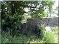
Llwybr ym Mhont ar Fr?n / Path at Pont ar Fr
Llwybr troed cyhoeddus yn cyrraedd yr A4069 wrth ymyl Pont ar Frân.
A public footpath joining the A4069 at Pont ar Frân (trans. crow [river] bridge).
Image: © Alan Richards
Taken: 30 Jun 2021
0.14 miles
2
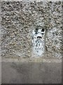
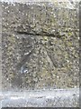
Ordnance Survey Flush Bracket (905)
This OS Flush Bracket (905) can be found on the front of a cottage at Wern-ystrad-Maerig. It was used during the Second Geodetic Levelling of England & Wales (1912-21) Carmarthen - Llandovery Levelling Line. Also the Third Geodetic Levelling of England & Wales (1950-68) Llandovery - Carmarthen Levelling Line. It marks a point 171.9950ft above mean sea level.
Image: © Adrian Dust
Taken: 2 Jun 2013
0.17 miles
3
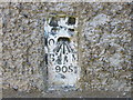
Ordnance Survey Flush Bracket 905
This can be found on the wall of Ystrad Cottage - a private dwelling.
For more detail see : http://www.bench-marks.org.uk/bm10020
Image: © Peter Wood
Taken: 20 Apr 2015
0.17 miles
4
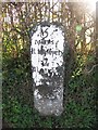
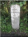
Old Milestone by the A4069, Bran Mill, Llangadog
Milestone by the A4069, in parish of Llangadog (Carmarthenshire District), Llangadog, near Bran Mill.
Inscription reads:-
5
Miles
Llandovery
7
Llandilo
Grade II listed by Cadw.
Reference Number 21971: https://cadwpublic-api.azurewebsites.net/reports/listedbuilding/FullReport?lang=&id=21971
Surveyed
Milestone Society National ID: CAM_LDLL05
Image: © Milestone Society
Taken: Unknown
0.19 miles
5
Mile Stone
Llandovery 5, Llandeilo 7, Llangadog 1/4. To the south of the road.
Image: © Adrian Dust
Taken: 18 Aug 2013
0.19 miles
6
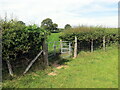
Llwybr i'r A4069 / Path to the A4069
Llwybr troed cyhoeddus yn arwain at yr A4069.
A public footpath heading towards the A4069.
Image: © Alan Richards
Taken: 30 Jun 2021
0.20 miles
7
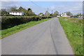
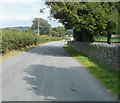
Road approaching Llangadog
Country road approaching the village Llangadog.
Image: © Philip Halling
Taken: 13 May 2012
0.21 miles
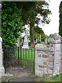
9
Ordnance Survey Cut Mark
This OS cut mark can be found on the Cemetery Gatepost. It marks a point 56.0222m above mean sea level.
Image: © Adrian Dust
Taken: 18 Aug 2013
0.23 miles
10
Pen-y-graig Road, Llangadog
The view east from alongside the perimeter wall of Llangadog Cemetery.
Image: © Jaggery
Taken: 3 Jul 2011
0.23 miles