IMAGES TAKEN NEAR TO
LLANGADOG, SA19 9DB
Introduction
This page details the photographs taken nearby to SA19 9DB by members of the Geograph project.
The Geograph project started in 2005 with the aim of publishing, organising and preserving representative images for every square kilometre of Great Britain, Ireland and the Isle of Man.

There are currently over 7.5m images from over14,400 individuals and you can help contribute to the project by visiting https://www.geograph.org.uk
Image Map (Loading...)


Getting Data...Please wait
Leaflet Map data © OpenStreetMap
Images are licensed for reuse under creativecommons.org/licenses/by-sa/2.0
Notes
- Clicking on the map will re-center to the selected point.
- The higher the marker number, the further away the image location is from the centre of the postcode.
Image Listing (5 Images Found)
Images are licensed for reuse under creativecommons.org/licenses/by-sa/2.0
Image
Details
Distance
1
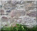
Ordnance Survey Cut Mark
This OS cut mark can be found on the barn conversion west side of the road. It marks a point 46.216m above mean sea level.
Image: © Adrian Dust
Taken: 2 Jul 2020
0.06 miles
2

Old mill building, Godregarreg
Water is carried across the common in a long-disused leat which runs on
the top of the wall and into the building. There is no obvious
watercourse on the other side, despite the blue line on the map. The wall of the leat is constructed from the local, red, characteristic sandstone.
Image: © Jonathan Wilkins
Taken: 27 Jul 2007
0.13 miles
3

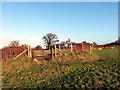
Godregarreg
Farm on the edge of Carreg Sawdde Common.
Image: © Jonathan Wilkins
Taken: 27 Jul 2007
0.17 miles
4
Llwybr Ffarm Bryngwyn / Bryngwyn Farm Path
Llwybr cyhoeddus yn mynd i dreflan Felindre o gyfeiriad Ffarm Bryngwyn.
A public footpath heading in the direction of Felindre (trans. mill farm) from Bryngwyn Farm (trans. fair/ white hill).
Image: © Alan Richards
Taken: 26 Dec 2016
0.23 miles
5

Carreg Sawdde Common
Damp pasture near to the confluence of the Afon Sawdde with the Afon Tywi.
Image: © Jonathan Wilkins
Taken: 27 Jul 2007
0.25 miles