IMAGES TAKEN NEAR TO
Ffaldybrenin, LLANWRDA, SA19 8QB
Introduction
This page details the photographs taken nearby to Ffaldybrenin, SA19 8QB by members of the Geograph project.
The Geograph project started in 2005 with the aim of publishing, organising and preserving representative images for every square kilometre of Great Britain, Ireland and the Isle of Man.

There are currently over 7.5m images from over14,400 individuals and you can help contribute to the project by visiting https://www.geograph.org.uk
Image Map
Images are licensed for reuse under creativecommons.org/licenses/by-sa/2.0
Notes
- Clicking on the map will re-center to the selected point.
- The higher the marker number, the further away the image location is from the centre of the postcode.
Image Listing (6 Images Found)
Images are licensed for reuse under creativecommons.org/licenses/by-sa/2.0
Image
Details
Distance
1
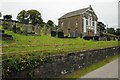
Chapel in Ffaldybrenin
Chapel and graveyard of the small village of Ffaldybrenin.
Image: © Philip Halling
Taken: 20 Sep 2015
0.03 miles
2
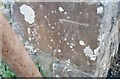
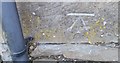
Ordnance Survey Cut Mark
This OS cut mark can be found on the house on the south side of the road. It marks a point 214.113m above mean sea level.
Image: © Adrian Dust
Taken: 4 Dec 2016
0.04 miles
3
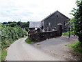
Ffaldybrenin
Yn cyrraedd pentre Ffaldybrenin gyda chefn y capel ar y dde.
Arriving at the village of Ffaldybrenin (trans. the king's pound) with the rear of the chapel on the right.
Image: © Alan Richards
Taken: 4 Aug 2017
0.04 miles
4
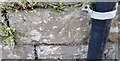
Ordnance Survey Cut Mark
This OS cut mark can be found on the north east angle of the school. It marks a point 211.934m above mean sea level.
Image: © Adrian Dust
Taken: 4 Dec 2016
0.09 miles
5
Ordnance Survey Cut Mark
This OS cut mark can be found on the house at Penrhiwcelyn. It marks a point 207.730m above mean sea level.
Image: © Adrian Dust
Taken: 4 Dec 2016
0.18 miles
6
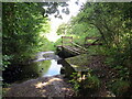
Rhyd Camnant / Camnant ford
Llwybr yn rhydio nant Camnant. Sylwer ar y bompren bydredig.
A path fords Camnant (trans. crooked stream). Note the dilapidated footbridge.
Image: © Alan Richards
Taken: 26 Aug 2022
0.23 miles