IMAGES TAKEN NEAR TO
Harford, LLANWRDA, SA19 8DR
Introduction
This page details the photographs taken nearby to SA19 8DR by members of the Geograph project.
The Geograph project started in 2005 with the aim of publishing, organising and preserving representative images for every square kilometre of Great Britain, Ireland and the Isle of Man.

There are currently over 7.5m images from over14,400 individuals and you can help contribute to the project by visiting https://www.geograph.org.uk
Image Map (Loading...)


Getting Data...Please wait
Leaflet Map data © OpenStreetMap
Images are licensed for reuse under creativecommons.org/licenses/by-sa/2.0
Notes
- Clicking on the map will re-center to the selected point.
- The higher the marker number, the further away the image location is from the centre of the postcode.
Image Listing (8 Images Found)
Images are licensed for reuse under creativecommons.org/licenses/by-sa/2.0
Image
Details
Distance
1
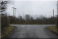
Road junction on the A482
Where a minor road from Ffaldybrenin meets the main road.
Image: © Nigel Brown
Taken: 29 Jan 2009
0.14 miles
2
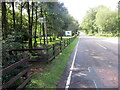
Llwybr yn gadael yr heol / Path exits the road
Llwybr cyhoeddus yn gadael yr A482.
Public footpath exits the A482.
Image: © Alan Richards
Taken: 26 Aug 2022
0.15 miles
3

Minor road to Ffaldybrenin
Just after leaving the A482.
Image: © Nigel Brown
Taken: 29 Jan 2009
0.15 miles
4
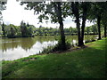
Pysgodfa Springwater / Springwater Fishery
Llwybr cyhoeddus yn mynd heibio i Bysgodfa Springwater.
A public footpath passes Springwater Fishery.
Image: © Alan Richards
Taken: 26 Aug 2022
0.16 miles
5
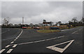
Road junction on the A482
With the road to Ffarmers heading off right.
Image: © Nigel Brown
Taken: 29 Jan 2009
0.22 miles
6
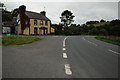
House on a road junction
This house beside the A482 at its junction with Sarn Helen, the former Roman Road has the appearance that it was once a public house.
Image: © Philip Halling
Taken: 20 Sep 2015
0.23 miles
7
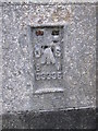
Ordnance Survey Flush Bracket (G3335)
This OS Flush Bracket can be found on the Royal Oak. It marks a point 174.677m above mean sea level.
Image: © Adrian Dust
Taken: 13 Jun 2014
0.24 miles
8
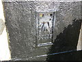
Ordnance Survey Flush Bracket G3335
This can be found on the former Royal Oak Hotel - now a private dwelling at the junction of the A482 and Sarn Helen roads.
For more detail see : http://www.bench-marks.org.uk/bm10592
Image: © Peter Wood
Taken: 20 Apr 2015
0.24 miles