IMAGES TAKEN NEAR TO
LLANWRDA, SA19 8AL
Introduction
This page details the photographs taken nearby to SA19 8AL by members of the Geograph project.
The Geograph project started in 2005 with the aim of publishing, organising and preserving representative images for every square kilometre of Great Britain, Ireland and the Isle of Man.

There are currently over 7.5m images from over14,400 individuals and you can help contribute to the project by visiting https://www.geograph.org.uk
Image Map
Images are licensed for reuse under creativecommons.org/licenses/by-sa/2.0
Notes
- Clicking on the map will re-center to the selected point.
- The higher the marker number, the further away the image location is from the centre of the postcode.
Image Listing (8 Images Found)
Images are licensed for reuse under creativecommons.org/licenses/by-sa/2.0
Image
Details
Distance
1
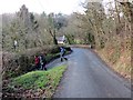
Cwmdwr
Cerddwyr yn gadael yr heol a dilyn llwybr cyhoeddus yng Nghwmdwr..
Walkers leaving the road to follow a public footpath in Cwmdwr (trans. river valley).
Image: © Alan Richards
Taken: 1 Feb 2015
0.01 miles
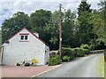
4
Cwmdwr
Country road off the A482 in Cwmdwr.
Image: © Philip Halling
Taken: 5 May 2013
0.06 miles
5
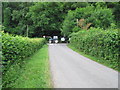
Tractor on the road
The tractor was going rather slowly. We'd been following it south along the A482, overtook it, and pulled into a lane. Here, the tractor continues along the A482 across the end of the lane towards Llanwdra.
Image: © Neville Goodman
Taken: 4 Jul 2009
0.10 miles
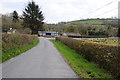
6
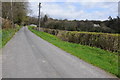
Country road near Abertrinant
Country road near Abertrinant to the north of Llanwrda.
Image: © Philip Halling
Taken: 5 May 2013
0.14 miles
7
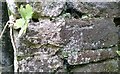
Ordnance Survey Cut Mark
This OS cut mark can be found on the barn at Cwmdwr. It marks a point 73.365m above mean sea level.
Image: © Adrian Dust
Taken: 7 Jul 2020
0.16 miles
8
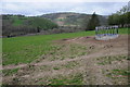
Feeding rack
Feeding rack in a field near Llanwrda.
Image: © Philip Halling
Taken: 5 May 2013
0.21 miles