IMAGES TAKEN NEAR TO
Pumpsaint, LLANWRDA, SA19 8AJ
Introduction
This page details the photographs taken nearby to SA19 8AJ by members of the Geograph project.
The Geograph project started in 2005 with the aim of publishing, organising and preserving representative images for every square kilometre of Great Britain, Ireland and the Isle of Man.

There are currently over 7.5m images from over14,400 individuals and you can help contribute to the project by visiting https://www.geograph.org.uk
Image Map
Images are licensed for reuse under creativecommons.org/licenses/by-sa/2.0
Notes
- Clicking on the map will re-center to the selected point.
- The higher the marker number, the further away the image location is from the centre of the postcode.
Image Listing (6 Images Found)
Images are licensed for reuse under creativecommons.org/licenses/by-sa/2.0
Image
Details
Distance
1
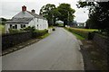
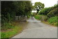
Sarn Helen south of Ffarmers
Sarn Helen is an old Roman Road here it is pictured crossing a stream to the south of the village of Ffarmers.
Image: © Philip Halling
Taken: 20 Sep 2015
0.01 miles
2
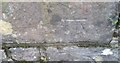
Ordnance Survey Cut Mark
This OS cut mark can be found on the west parapet of the bridge. It marks a point 150.145m above mean sea level.
Image: © Adrian Dust
Taken: 4 Dec 2016
0.02 miles
3
Sarn Helen south of Ffarmers
Sarn Helen is an old Roman Road here it is pictured crossing a stream to the south of the village of Ffarmer.
Image: © Philip Halling
Taken: 20 Sep 2015
0.03 miles
4
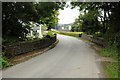
Sarn Helen south of Ffarmers
Heading straight along the flat, before it climbs round the hill ahead.
Image: © Nigel Brown
Taken: 13 May 2008
0.05 miles
5
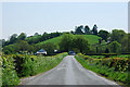
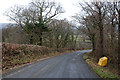
Minor country road
Minor country road in the Twrch valley to the south of Ffarmers.
Image: © Philip Halling
Taken: 20 Sep 2015
0.05 miles
6
Steep bit on Sarn Helen
Road heading downhill towards Ffarmers, along the line of Sarn Helen roman road.
Image: © Nigel Brown
Taken: 29 Jan 2009
0.12 miles