IMAGES TAKEN NEAR TO
Parc Cawdor, LLANDEILO, SA19 6SZ
Introduction
This page details the photographs taken nearby to Parc Cawdor, SA19 6SZ by members of the Geograph project.
The Geograph project started in 2005 with the aim of publishing, organising and preserving representative images for every square kilometre of Great Britain, Ireland and the Isle of Man.

There are currently over 7.5m images from over14,400 individuals and you can help contribute to the project by visiting https://www.geograph.org.uk
Image Map (Loading...)


Getting Data...Please wait
Leaflet Map data © OpenStreetMap
Images are licensed for reuse under creativecommons.org/licenses/by-sa/2.0
Notes
- Clicking on the map will re-center to the selected point.
- The higher the marker number, the further away the image location is from the centre of the postcode.
Image Listing (68 Images Found)
Images are licensed for reuse under creativecommons.org/licenses/by-sa/2.0
Image
Details
Distance
1
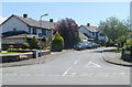
Cawdor Park, Ffairfach
Cawdor Park is a cul-de-sac on the south side of Bethlehem Road.
Image: © Jaggery
Taken: 26 Jun 2011
0.03 miles
2
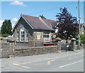
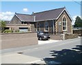
Ffairfach Primary School
Viewed across Bethlehem Road. Ffairfach Primary School (Ysgol Ffairfach in Welsh) is a Welsh Medium (Category A) primary school providing education via the medium of the Welsh language for pupils from 4-11 years old.
Image: © Jaggery
Taken: 26 Jun 2011
0.04 miles
3
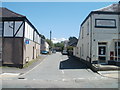
Railway Terrace, Ffairfach
Viewed across the A483 (Heol Cennen). On the right is the village post office. http://www.geograph.org.uk/photo/2548151
Don't be misled by the street name. It is a cul-de-sac heading towards the course of a long since dismantled railway. Ffairfach railway station is about 300 metres to the south of the post office, beyond the right edge of the view.
Image: © Jaggery
Taken: 26 Jun 2011
0.05 miles
4
Northern side of Ffairfach Primary School
Viewed from Railway Terrace, across the school boundary wall. The school entrance is from Bethlehem Road on the opposite side of the building. The school (Ysgol Gynradd Ffairfach in Welsh) is a Welsh Medium (Category A) primary school providing education for pupils aged 4-11.
Image: © Jaggery
Taken: 26 Jun 2011
0.05 miles
5
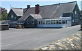
Llandeilo YFC hall, Ffairfach
The hall is located on Bethlehem Road about 50 metres east of crossroads http://www.geograph.org.uk/photo/3241901 in Ffairfach.
It is owned by Llandeilo YFC (Young Farmers Club), established in 1942, who meet here
every Tuesday from 7.30pm to 9pm. Young people aged 10-26 are welcome.
Image: © Jaggery
Taken: 26 Jun 2011
0.05 miles
6
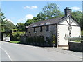
Former Lovelodge Mill, Ffairfach
Now in residential use, this was formerly a water-powered mill for grinding flour and animal feed.
Built in c1780. Last used in c1900.
Image: © Jaggery
Taken: 26 Jun 2011
0.06 miles
7
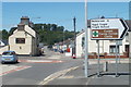
4 miles to Bethlehem from Ffairfach
The sign for Bethlehem is at crossroads in Ffairfach south of Llandeilo.
Image: © Jaggery
Taken: 26 Jun 2011
0.07 miles
8
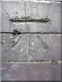
Ordnance Survey Cut Mark
This OS Cut Mark can be found on the side of a former shop at the Ffairfach crossroads. It marks a point 31.4249m above mean sea level.
Image: © Adrian Dust
Taken: 28 Jul 2013
0.07 miles
9
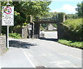
Low bridge
Crossing the unclassified road to Bethlehem and Llangadog, this bridge conspires to be narrow as well as low (12 feet).
Image: © Jonathan Wilkins
Taken: 18 Jul 2007
0.08 miles
10
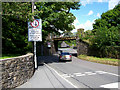
Bethlehem Road railway bridge, Ffairfach
Bethlehem Road passes under the Heart of Wales railway line, between Ffairfach station http://www.geograph.org.uk/photo/2925146 and Llandeilo station. Headroom (overhead clearance) is shown as 12ft.
Image: © Jaggery
Taken: 26 Jun 2011
0.08 miles