IMAGES TAKEN NEAR TO
LLANDEILO, SA19 6SF
Introduction
This page details the photographs taken nearby to SA19 6SF by members of the Geograph project.
The Geograph project started in 2005 with the aim of publishing, organising and preserving representative images for every square kilometre of Great Britain, Ireland and the Isle of Man.

There are currently over 7.5m images from over14,400 individuals and you can help contribute to the project by visiting https://www.geograph.org.uk
Image Map
Images are licensed for reuse under creativecommons.org/licenses/by-sa/2.0
Notes
- Clicking on the map will re-center to the selected point.
- The higher the marker number, the further away the image location is from the centre of the postcode.
Image Listing (7 Images Found)
Images are licensed for reuse under creativecommons.org/licenses/by-sa/2.0
Image
Details
Distance
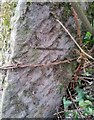
2
Ordnance Survey Cut Mark
This OS cut mark can be found on the concrete gatepost east side of the road. It marks a point 74.908m above mean sea level.
Image: © Adrian Dust
Taken: 15 Mar 2021
0.17 miles
3
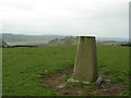
Triangulation Pillar (S2119)
Broad Oak Secondary Triangulation Pillar carries Flash Bracket S2119 which marks a point 149.964m above mean sea level.
Image: © Adrian Dust
Taken: 24 Mar 2008
0.21 miles
4
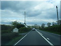
A40 east of Broad Oak
Running along the valley of Nant Stephanau.
Image: © Derek Harper
Taken: 2 Jan 2015
0.22 miles
5

Farmland at Wern-fawr
Taken from the A40 that passes through the south-eastern part of the square.
Image: © Graham Horn
Taken: 20 Oct 2008
0.24 miles
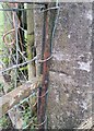
6
Ordnance Survey Cut Mark
This OS cut mark can be found on the broken stone gatepost NW side of the road. It marked a point 48.527m above mean sea level.
Image: © Adrian Dust
Taken: 20 Mar 2021
0.24 miles
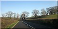
7

Farmland at Wern-fawr
Off the A40 and looking north, more pasture in the lower lying parts of the square.
Image: © Graham Horn
Taken: 20 Oct 2008
0.25 miles