IMAGES TAKEN NEAR TO
Clarence Road, LLANDEILO, SA19 6HY
Introduction
This page details the photographs taken nearby to Clarence Road, SA19 6HY by members of the Geograph project.
The Geograph project started in 2005 with the aim of publishing, organising and preserving representative images for every square kilometre of Great Britain, Ireland and the Isle of Man.

There are currently over 7.5m images from over14,400 individuals and you can help contribute to the project by visiting https://www.geograph.org.uk
Image Map
Images are licensed for reuse under creativecommons.org/licenses/by-sa/2.0
Notes
- Clicking on the map will re-center to the selected point.
- The higher the marker number, the further away the image location is from the centre of the postcode.
Image Listing (120 Images Found)
Images are licensed for reuse under creativecommons.org/licenses/by-sa/2.0
Image
Details
Distance
1
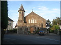
Wesleyan Methodist Chapel
In Latimer Road. This chapel was built by J W Jones in 1900 and has been converted into private accommodation.
Image: © Trevor Rickard
Taken: 22 Aug 2007
0.04 miles
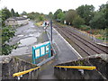
2
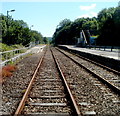
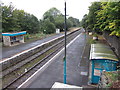
Llandeilo railway station
Viewed from this level crossing. http://www.geograph.org.uk/photo/3273933 Llandeilo is a station on the Heart of Wales line, between Ffairfach station to the south and Llangadog station to the north.
Image: © Jaggery
Taken: 26 Jun 2011
0.06 miles
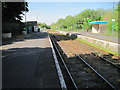
3
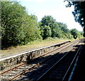
Southern end of platform 1, Llandeilo railway station
Viewed from platform 2.
Llandeilo is a station on the Heart of Wales line. Platform 1 is for arrivals from Shrewsbury and other stations north of Llandeilo, and for departures south to all stations to Swansea. The next station ahead is Ffairfach http://www.geograph.org.uk/photo/2925146, about a mile (c1.6km) away.
Image: © Jaggery
Taken: 26 Jun 2011
0.06 miles
6
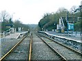
Llandeilo railway station
This station is on a dead-end road on the outskirts of town. It is also much lower than most of the town.
This shot is taken from a legitimate pedestrian crossing point between the two platfoms.
Although two lines are pictured, there is only one real line for the Heart of Wales here. A token system is in operation so that trains only pass one direction at a time.
Image: © Nigel Davies
Taken: 25 Feb 2007
0.08 miles
7
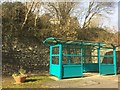
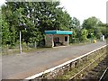
Railway shelter
Shelter on the railway station at Llandeilo.
Image: © Alan Hughes
Taken: 24 Feb 2019
0.08 miles
8
Llandeilo station
Some of the stations on the Central Wales line are 'request stops', but Llandeilo is a fixed stop.
Image: © Dr Neil Clifton
Taken: 27 Jul 2012
0.08 miles
10
Llandeilo railway station, Carmarthenshire
Opened in 1852 by the 'Llanelly Railway' on the line from Llanelli, the route was later extended northwards and by linking up with other lines, created a through route to Llandrindod Wells, Church Stretton and Shrewsbury. It became known as the Central Wales Line.
View north east towards Talley Road Halt and Llandrindod. From 1865 to 1963, this was also the junction for the line to Carmarthen. Compared to Image from the right-hand platform, the signalbox and station buildings have both been removed,
Image: © Nigel Thompson
Taken: 17 May 2014
0.08 miles