IMAGES TAKEN NEAR TO
Pentreguinea Road, SWANSEA, SA1 8DL
Introduction
This page details the photographs taken nearby to Pentreguinea Road, SA1 8DL by members of the Geograph project.
The Geograph project started in 2005 with the aim of publishing, organising and preserving representative images for every square kilometre of Great Britain, Ireland and the Isle of Man.

There are currently over 7.5m images from over14,400 individuals and you can help contribute to the project by visiting https://www.geograph.org.uk
Image Map (Loading...)


Getting Data...Please wait
Leaflet Map data © OpenStreetMap
Images are licensed for reuse under creativecommons.org/licenses/by-sa/2.0
Notes
- Clicking on the map will re-center to the selected point.
- The higher the marker number, the further away the image location is from the centre of the postcode.
Image Listing (56 Images Found)
Images are licensed for reuse under creativecommons.org/licenses/by-sa/2.0
Image
Details
Distance
1
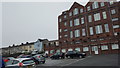
Swansea : St Thomas School Apartments
The old school was converted into residential flats.
Image: © Lewis Clarke
Taken: 15 Jul 2017
0.05 miles
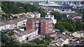
3
Across the Tawe in Swansea
A view from the edge of New Cut Road across the River Tawe looking towards the St Thomas district of Swansea. The river is about 60 metres wide here.
Image: © Jaggery
Taken: 10 Nov 2013
0.06 miles
4
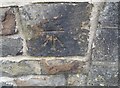
Ordnance Survey Cut Mark
This OS cut mark can be found on the wall SW side of Windmill Terrace. It marks a point 38.661m above mean sea level.
Image: © Adrian Dust
Taken: 14 Apr 2019
0.07 miles
5
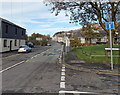
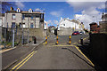
Pentreguinea Road, Swansea
Pentreguinea Road heads NNW away from Delhi Street
past The Ship http://www.geograph.org.uk/photo/3741420 on the left. The Morris Lane junction is on the right.
Image: © Jaggery
Taken: 10 Nov 2013
0.08 miles
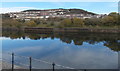
6
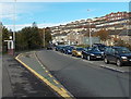
East Bank Way, Swansea
Looking north along the east bank of the River Tawe towards Pentreguinea Road.
Image: © Jaggery
Taken: 10 Nov 2013
0.08 miles
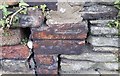
7
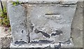
Ordnance Survey Cut Mark
This badly damaged OS cut mark can be found on the gatepost of No26 Benthall Place It marks a point 18.239m above mean sea level.
Image: © Adrian Dust
Taken: 14 Apr 2019
0.09 miles
8
Ordnance Survey Cut Mark
This OS cut mark can be found on the wall of No67 Windmill Terrace. It marks a point 43.900m above mean sea level.
Image: © Adrian Dust
Taken: 14 Apr 2019
0.10 miles
9
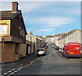
Morris Lane, Swansea
Housing development on the lower slopes of Kilvey Hill.
Image: © Bill Boaden
Taken: 5 Apr 2016
0.10 miles
10
Miers Street, Swansea
Looking north from Delhi Street past the City bar http://www.geograph.org.uk/photo/3741505 along Miers Street towards Mackworth Terrace.
Image: © Jaggery
Taken: 10 Nov 2013
0.11 miles