IMAGES TAKEN NEAR TO
New Cut Road, SWANSEA, SA1 8AP
Introduction
This page details the photographs taken nearby to New Cut Road, SA1 8AP by members of the Geograph project.
The Geograph project started in 2005 with the aim of publishing, organising and preserving representative images for every square kilometre of Great Britain, Ireland and the Isle of Man.

There are currently over 7.5m images from over14,400 individuals and you can help contribute to the project by visiting https://www.geograph.org.uk
Image Map
Images are licensed for reuse under creativecommons.org/licenses/by-sa/2.0
Notes
- Clicking on the map will re-center to the selected point.
- The higher the marker number, the further away the image location is from the centre of the postcode.
Image Listing (263 Images Found)
Images are licensed for reuse under creativecommons.org/licenses/by-sa/2.0
Image
Details
Distance
1
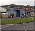
Halfords Autocentre, Swansea
Viewed across New Cut Road. A Screwfix store is next door.
Image: © Jaggery
Taken: 10 Nov 2013
0.00 miles
2
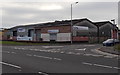
Hire One, Swansea
The Swansea branch of Hire One tool and plant hire is on the corner of New Cut Road and The Strand.
Image: © Jaggery
Taken: 10 Nov 2013
0.01 miles
3
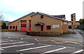
Swansea Central Fire Station
Located in The Strand, on the west side of the A483 New Cut Road, this station was built in 1992.
It covers Swansea city centre and the surrounding areas of Penlan, Blaenymaes, St Thomas, Bonymaen and Hafod. It is the busiest station in the Mid and West Wales Fire and Rescue Service.
Image: © Jaggery
Taken: 10 Nov 2013
0.05 miles
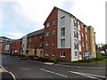
4
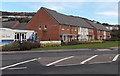
Llais Tawe show homes, Swansea
Viewed across New Cut Road. The show homes are part of a Bellway development on the west bank of the River Tawe. The Bellway sales and marketing suite is on the left.
Image: © Jaggery
Taken: 10 Nov 2013
0.06 miles
5
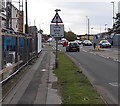
Fire station : stop when lights show, Swansea
The traffic sign is alongside New Cut Road. The lights are ahead, on the corner of Pottery Street, http://www.geograph.org.uk/photo/3739125 near the junction with The Strand, the location of Swansea Central Fire Station. http://www.geograph.org.uk/photo/3738745
Image: © Jaggery
Taken: 10 Nov 2013
0.07 miles
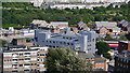
6
High Street Car Park, Swansea
Multistorey car park between High Street and Strand.
Image: © Jaggery
Taken: 8 Mar 2018
0.08 miles
7
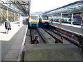
Platforms 1 and 2 viewed from the buffers, Swansea railway station
All trains at Swansea station must reverse out, using the mile-long spur to the South Wales main line.
Image: © Jaggery
Taken: 26 Feb 2012
0.09 miles
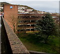
9
Pottery Street houses, Swansea
New housing located between New Cut Road and the River Tawe. The name Pottery Street has been revived. A street of that name (probably nearby rather than in this exact location) was demolished in the 1970s.
Image: © Jaggery
Taken: 10 Nov 2013
0.09 miles
10

Ordnance Survey Cut Mark
This OS cut mark can be found on the wall NW side of The Strand. It marks a point 8.2997m above mean sea level.
Image: © Adrian Dust
Taken: 30 Nov 2018
0.09 miles