IMAGES TAKEN NEAR TO
Heol Marlais, AMMANFORD, SA18 3UY
Introduction
This page details the photographs taken nearby to Heol Marlais, SA18 3UY by members of the Geograph project.
The Geograph project started in 2005 with the aim of publishing, organising and preserving representative images for every square kilometre of Great Britain, Ireland and the Isle of Man.

There are currently over 7.5m images from over14,400 individuals and you can help contribute to the project by visiting https://www.geograph.org.uk
Image Map (Loading...)


Getting Data...Please wait
Leaflet Map data © OpenStreetMap
Images are licensed for reuse under creativecommons.org/licenses/by-sa/2.0
Notes
- Clicking on the map will re-center to the selected point.
- The higher the marker number, the further away the image location is from the centre of the postcode.
Image Listing (33 Images Found)
Images are licensed for reuse under creativecommons.org/licenses/by-sa/2.0
Image
Details
Distance
1
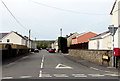
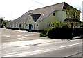
Blaenau Road houses, Llandybie
Viewed across a side road below the B4556 Blaenau Road.
Image: © Jaggery
Taken: 23 Apr 2015
0.11 miles
2
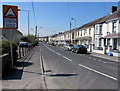
Margaret Road, Llandybie
Viewed from the west side of the A483 Ammanford Road.
Image: © Jaggery
Taken: 1 May 2015
0.12 miles
3
Woodfield Road, Llandybie
Looking SW from near the Ammanford Road junction. A bilingual sign shows Humps for 100 yards.
Image: © Jaggery
Taken: 23 Apr 2015
0.12 miles
4
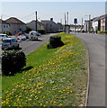
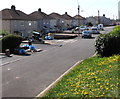
Yellow and green bank in Llandybie
In late April 2015, the yellows in the bank on the side of Blaenau Road are dandelions.
A few weeks earlier, daffodils were the main creators of natural yellow in the village.
Image: © Jaggery
Taken: 23 Apr 2015
0.13 miles
5
Public Memorial Hall, Llandybie
Viewed across Woodfield Road. Dated December 27th 1924, the dedication on the foundation stone is to the memory of the men of Llandybie who fell in the Great War. On the stone, Llandybie is spelt LLANDEBIE. It is highly unlikely that a spelling error would be allowed to remain on such an inscription, so it looks like Llandebie was the prevalent spelling nearly a century ago.
Image: © Jaggery
Taken: 23 Apr 2015
0.15 miles
6
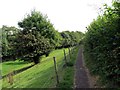
Llwybr Llandybie Path
Llwybr cyhoeddus yn arwain o gae rygbi Llandybie.
A public footpath heading from Llandybie rugby field.
Image: © Alan Richards
Taken: 13 Sep 2014
0.16 miles
7

Maespiode, Llandybie
Viewed across Blaenau Road. A nearby street name sign shows that Maespiode leads to Glanmarlais.
Image: © Jaggery
Taken: 23 Apr 2015
0.17 miles
8
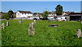
Gorsedd stone circle, Llandybie
Located on a bank of the Afon Marlas, east of Woodfield Road. The circle was used for the 1944 National Eisteddfod which was held in Llandybie during wartime hardship. The village welcomed numerous visitors from many allied countries.
The proclamation ceremony and other gorsedd ceremonies were held within the circle. The rectangular central stone is the maen gorsedd (gorsedd stone). The basic meaning of the Welsh word gorsedd is throne. It is used in English for the assembly (of bards) at an eisteddfod.
Image: © Jaggery
Taken: 23 Apr 2015
0.19 miles
9
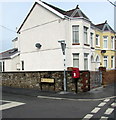
Queen Elizabeth II postbox on a Llandybie corner
On the corner of Margaret Road and the A483 Ammanford Road in Llandybie.
Image: © Jaggery
Taken: 1 May 2015
0.20 miles
10
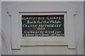
Gosen Chapel,Llandybie
Engraved sign on the wall of Gosen Chapel in Blaenau Road, Llandybie.
Image: © John B R Davies
Taken: 26 Mar 2007
0.20 miles