IMAGES TAKEN NEAR TO
Cwmfferws Road, AMMANFORD, SA18 3UD
Introduction
This page details the photographs taken nearby to Cwmfferws Road, SA18 3UD by members of the Geograph project.
The Geograph project started in 2005 with the aim of publishing, organising and preserving representative images for every square kilometre of Great Britain, Ireland and the Isle of Man.

There are currently over 7.5m images from over14,400 individuals and you can help contribute to the project by visiting https://www.geograph.org.uk
Image Map (Loading...)


Getting Data...Please wait
Leaflet Map data © OpenStreetMap
Images are licensed for reuse under creativecommons.org/licenses/by-sa/2.0
Notes
- Clicking on the map will re-center to the selected point.
- The higher the marker number, the further away the image location is from the centre of the postcode.
Image Listing (3 Images Found)
Images are licensed for reuse under creativecommons.org/licenses/by-sa/2.0
Image
Details
Distance
1
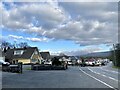
Housing estate
Houses on the road from Saron to Ammanford.
Image: © Alan Hughes
Taken: 10 Feb 2021
0.06 miles
2
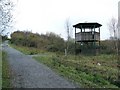
Viewing Tower in Allt Nant-y-Ci Recreation Park
Disused land has been turned into a small park through the addition of pathways, bridges and some structures.
The major path visible in the shot is a former railway to an old shaft marked 1Km west up hill on the map. This path is now a bridleway running through the park from the entrance and carpark to the east.
Image: © Nigel Davies
Taken: 21 Nov 2010
0.13 miles
3
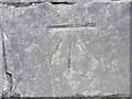
Ordnance Survey Cut Mark
This OS Cut Mark can be found on the south parapet of the bridge. It marks a point 55.8973m above mean sea level.
Image: © Adrian Dust
Taken: 21 Jul 2013
0.21 miles