IMAGES TAKEN NEAR TO
Dyffryn Road, AMMANFORD, SA18 3SU
Introduction
This page details the photographs taken nearby to Dyffryn Road, SA18 3SU by members of the Geograph project.
The Geograph project started in 2005 with the aim of publishing, organising and preserving representative images for every square kilometre of Great Britain, Ireland and the Isle of Man.

There are currently over 7.5m images from over14,400 individuals and you can help contribute to the project by visiting https://www.geograph.org.uk
Image Map
Images are licensed for reuse under creativecommons.org/licenses/by-sa/2.0
Notes
- Clicking on the map will re-center to the selected point.
- The higher the marker number, the further away the image location is from the centre of the postcode.
Image Listing (102 Images Found)
Images are licensed for reuse under creativecommons.org/licenses/by-sa/2.0
Image
Details
Distance
1
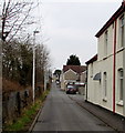
Brynderwen Road, Ammanford
On the north side of Station Road, Brynderwen Road runs parallel with the single-track
Heart of Wales railway line out of shot on the left. The edge of the Great Western pub http://www.geograph.org.uk/photo/4345170 is on the right.
Image: © Jaggery
Taken: 11 Feb 2015
0.03 miles
2
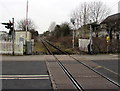
Heart of Wales Line north from Ammanford station towards Llandybie
Viewed from the edge of Ammanford railway station looking past the Station Road level crossing.
Llandybie station is about 3km ahead.
Image: © Jaggery
Taken: 11 Feb 2015
0.04 miles
3
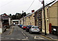
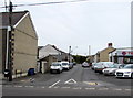
Harold Street, Ammanford
Viewed from Station Road. Harold Street extends west for 170 metres,
to Brynderwen Road at the edge of the Heart of Wales railway.
Image: © Jaggery
Taken: 11 Feb 2015
0.04 miles
4
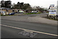
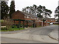
Southern end of Shands Road, Ammanford
Shands Road heads north away from Station Road near Ammanford railway station.
Image: © Jaggery
Taken: 11 Feb 2015
0.04 miles
5
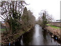
Upstream along the Loughor, Ammanford
River north of Station Road.
Image: © Jaggery
Taken: 11 Feb 2015
0.04 miles
6
Heol Haydn, Gwyn Fryn Estate, Ammanford
On the east side of Rhodfa Frank.
Image: © Jaggery
Taken: 11 Feb 2015
0.05 miles
7
Houses between Rhodfa Frank and Heol Haydn in Ammanford
Looking east across Rhodfa Frank.
Image: © Jaggery
Taken: 11 Feb 2015
0.07 miles
8
West along Florence Road, Ammanford
Viewed across Llandybie Road. T K Beynon used car dealer http://www.geograph.org.uk/photo/4455673 is on the right.
Image: © Jaggery
Taken: 1 May 2015
0.07 miles
9
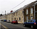
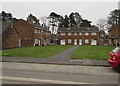
Harold Street houses in Ammanford
A few roofs have solar panels in February 2015. There were none in a Google Earth Street View in July 2011.
Image: © Jaggery
Taken: 11 Feb 2015
0.08 miles
10
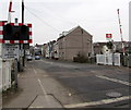
Keep Crossing Clear, Station Road, Ammanford
The level crossing is at the intersection of the Heart of Wales railway
and Station Road, a few metres north of Ammanford railway station.
Image: © Jaggery
Taken: 11 Feb 2015
0.09 miles