IMAGES TAKEN NEAR TO
Capel Hendre, AMMANFORD, SA18 3RT
Introduction
This page details the photographs taken nearby to SA18 3RT by members of the Geograph project.
The Geograph project started in 2005 with the aim of publishing, organising and preserving representative images for every square kilometre of Great Britain, Ireland and the Isle of Man.

There are currently over 7.5m images from over14,400 individuals and you can help contribute to the project by visiting https://www.geograph.org.uk
Image Map
Images are licensed for reuse under creativecommons.org/licenses/by-sa/2.0
Notes
- Clicking on the map will re-center to the selected point.
- The higher the marker number, the further away the image location is from the centre of the postcode.
Image Listing (8 Images Found)
Images are licensed for reuse under creativecommons.org/licenses/by-sa/2.0
Image
Details
Distance
1
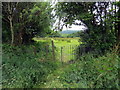
Llwybr Capel Hendre / Capel Hendre Path
Llwybr cyhoeddus yn gadael pentre Capel Hendre ac sy'n mynd i gyfeiriad Cwmgwili.
A public footpath leaving Capel Hendre (trans. chapel of the winter dwelling) and heading towards Cwmgwili (trans. valley of the Gwili [river]).
Image: © Alan Richards
Taken: 15 Jun 2018
0.05 miles
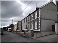
2
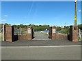
Gate to King George V Field at Capel Hendre
There is no maintained grass pitch here. There is a playground and a court within a wider area of rough grass.
The regulation lion and unicorn plaques are present on the inner pillars but the stone relief has weathered away a little over time.
The black plaque on the far right pillar is a WWII war memorial for those from Capel Hendre.
Image: © Nigel Davies
Taken: 27 Sep 2015
0.06 miles
5
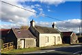
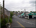
Derelict buildings
Derelict buildings in Waterloo Road, Capel Hendre.
Image: © Alan Hughes
Taken: 19 Nov 2018
0.16 miles
7
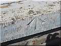
Ordnance Survey Rivet
This Ordnance Survey Rivet with Broad Arrow can be found on the window ledge of No118 Waterloo Road. It marks a point 145.2400m above mean sea level.
Image: © Adrian Dust
Taken: 9 Jun 2013
0.17 miles
8
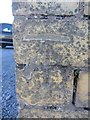
Ordnance Survey Cut Mark
This Ordnance Survey Cut Mark can be found on the front of the Kings Head PH. It marks a point 138.7907m above mean sea level.
Image: © Adrian Dust
Taken: 9 Jun 2013
0.24 miles