IMAGES TAKEN NEAR TO
Ffrwd Y Felin, AMMANFORD, SA18 3NP
Introduction
This page details the photographs taken nearby to Ffrwd Y Felin, SA18 3NP by members of the Geograph project.
The Geograph project started in 2005 with the aim of publishing, organising and preserving representative images for every square kilometre of Great Britain, Ireland and the Isle of Man.

There are currently over 7.5m images from over14,400 individuals and you can help contribute to the project by visiting https://www.geograph.org.uk
Image Map
Images are licensed for reuse under creativecommons.org/licenses/by-sa/2.0
Notes
- Clicking on the map will re-center to the selected point.
- The higher the marker number, the further away the image location is from the centre of the postcode.
Image Listing (28 Images Found)
Images are licensed for reuse under creativecommons.org/licenses/by-sa/2.0
Image
Details
Distance
1
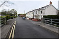
Aberlash Road houses near Ammanford
Looking SW from the bridge over a river, Afon Marlas.
Image: © Jaggery
Taken: 1 May 2015
0.09 miles
2
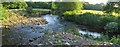
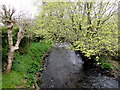
Confluence of Rivers Loughor and Marlais
On the left, the Loughor approaches from the east, on the right, the Marlais approaches from the north. The river continues southwest into the distance as the Loughor.
Image: © Nigel Davies
Taken: 23 Jun 2005
0.09 miles
3
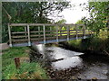
Pompren Afon Llwchwr Footbridge
Pompren yn rhychwantu Afon Llwchwr ger pentre Bonllwyn.
A footbridge spanning the Llwchwr (Loughor) near Bonllwyn village (trans. foot of bush)
Image: © Alan Richards
Taken: 13 Sep 2014
0.14 miles
4

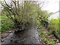
Confluence of the Lash and the Loughor
The Loughor flows from right to left. The Lash enters from back of shot, creating a small pebble beach on the SE bank of the Loughor from which this photo is taken.
Image: © Nigel Davies
Taken: 22 Mar 2022
0.14 miles
5
Downstream along Afon Marlas near Ammanford
Viewed from this http://www.geograph.org.uk/photo/4457298 Aberlash Road bridge, the Marlas flows towards its confluence with the River Loughor.
Image: © Jaggery
Taken: 1 May 2015
0.15 miles
6
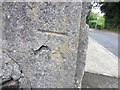
Ordnance Survey Cut Mark
This OS cut mark can be seen on the bridge over the Nant Gwinau. It marks a point 42.5714m above mean sea level.
Image: © Adrian Dust
Taken: 24 Aug 2013
0.17 miles
7
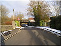
Two bridges
In front, the road bridge over the river. Beyond, the railway bridge with the very low headroom of 7 feet 9 inches.
Image: © Marion Phillips
Taken: 2 Dec 2010
0.17 miles
8
Upstream along the Afon Marlas from Aberlash Road near Ammanford
Viewed from the Aberlash Road bridge. http://www.geograph.org.uk/photo/4457298
Image: © Jaggery
Taken: 1 May 2015
0.18 miles
9
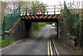
West side of a low railway bridge, Aberlash Road near Ammanford
The road passes under the Heart of Wales railway. Overhead clearance shown is 7' 9". Below the headroom sign, a small metal plate records that the bridge was made in 1912 by E.Finch & Co Ltd of Chepstow, engineers and iron founders.
Image: © Jaggery
Taken: 1 May 2015
0.19 miles
10
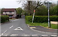
Aberlash Road near Ammanford
Viewed from the A483 looking towards a low railway bridge. http://www.geograph.org.uk/photo/4457182
Image: © Jaggery
Taken: 1 May 2015
0.19 miles