IMAGES TAKEN NEAR TO
Hendre Road, AMMANFORD, SA18 3LA
Introduction
This page details the photographs taken nearby to Hendre Road, SA18 3LA by members of the Geograph project.
The Geograph project started in 2005 with the aim of publishing, organising and preserving representative images for every square kilometre of Great Britain, Ireland and the Isle of Man.

There are currently over 7.5m images from over14,400 individuals and you can help contribute to the project by visiting https://www.geograph.org.uk
Image Map (Loading...)


Getting Data...Please wait
Leaflet Map data © OpenStreetMap
Images are licensed for reuse under creativecommons.org/licenses/by-sa/2.0
Notes
- Clicking on the map will re-center to the selected point.
- The higher the marker number, the further away the image location is from the centre of the postcode.
Image Listing (9 Images Found)
Images are licensed for reuse under creativecommons.org/licenses/by-sa/2.0
Image
Details
Distance
1
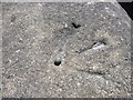
Ordnance Survey Rivet
This Ordnance Survey NBM Rivet with Broad Arrow can be found on the N Parapet of Hendre Road Bridge. It marks a point 63.8861m above mean sea level.
Image: © Adrian Dust
Taken: 9 Jun 2013
0.09 miles
2
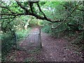
Llwybr Cwm Saeson Path
Gât fochyn ar lwybr cyhoeddus ger anhedd-dy o'r enw Cwm Saeson er taw Nant Arw yw'r ffrwd a lifa i lawr y cwm.
A kissing gate on a public footpath near a property called Cwm Saeson (trans. Englishmen's valley. However, the name of the stream that flows down the valley is known as Nant Arw (trans. rough stream).
Image: © Alan Richards
Taken: 26 Jul 2014
0.14 miles
3
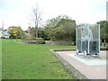
Fferws Park near Tycroes
There doesn't seem to be any information on the site as to the significance of the flywheel-in-a-cage-on-rails sculpture.
Image: © Nigel Davies
Taken: 27 Oct 2005
0.17 miles
4
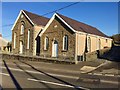
Caersalem Calvinistic chapel
Non-conformist Chapel on Heol Rhydaman, Tycroes.
Image: © Alan Hughes
Taken: 14 Feb 2019
0.18 miles
5
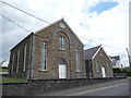
Caersalem Calvinistic Methodist chapel, Tycroes
Dated 1878 and in a very good state of repair by the look of things.
Image: © Jeremy Bolwell
Taken: 4 Jun 2012
0.18 miles
6
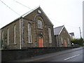
Caersalem Chapel
Nonconformist chapel, built in 1872.
Image: © Marion Phillips
Taken: 4 Nov 2010
0.21 miles
8
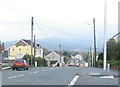
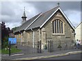
A483 descends to Tycroes
This is the view northeast downhill on the main road through Tycroes.
Image: © Nigel Davies
Taken: 28 Oct 2005
0.23 miles