IMAGES TAKEN NEAR TO
Wind Street, AMMANFORD, SA18 3DN
Introduction
This page details the photographs taken nearby to Wind Street, SA18 3DN by members of the Geograph project.
The Geograph project started in 2005 with the aim of publishing, organising and preserving representative images for every square kilometre of Great Britain, Ireland and the Isle of Man.

There are currently over 7.5m images from over14,400 individuals and you can help contribute to the project by visiting https://www.geograph.org.uk
Image Map
Images are licensed for reuse under creativecommons.org/licenses/by-sa/2.0
Notes
- Clicking on the map will re-center to the selected point.
- The higher the marker number, the further away the image location is from the centre of the postcode.
Image Listing (78 Images Found)
Images are licensed for reuse under creativecommons.org/licenses/by-sa/2.0
Image
Details
Distance
1
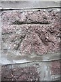
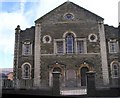
Ordnance Survey Cut Mark
This Ordnance Survey Cut Mark can be found on the front of the Ammanford Evangelical Church. The OS call this building 'The English Methodist Church'. It marks a point 36.4053m above mean sea level.
Image: © Adrian Dust
Taken: 20 Jun 2013
0.03 miles
2
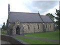
St Michael's Church, Ammanford
Welsh language church
Image: © John Lord
Taken: 8 Aug 2009
0.05 miles
3
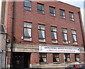
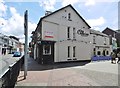
Miners' Welfare Club, Rhydaman/Ammanford
Built in the 20's from funds raised by the workers themselves, this was once an important focus of local community and cultural life It provided a venue for visiting speakers, political debate, educational and recreational activities as well as source of mutual support during strikes. Nowadays it is largely a drinking club but the top floor has been turned into a small mining museum which is well worth visiting.
Image: © Natasha Ceridwen de Chroustchoff
Taken: 4 Oct 2006
0.06 miles
4
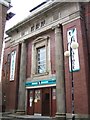
Miners' Theatre, Rhydaman/Ammanford
Originally built in the early 1930's, with money raised by public subscription, as a cinema, its ornate interior decor with elaborate plaster moulding has recently been beautifully refurbished and it now operates as a venue for live entertainment. It is tucked away behind the Miners Welfare Club of which it was once part.
Image: © Natasha Ceridwen de Chroustchoff
Taken: 4 Oct 2006
0.06 miles
6
Ammanford Post Office
Surviving Crown post office on Quay Street.
Image: © Mike Faherty
Taken: 14 Jul 2016
0.08 miles
7
Ammanford, Old Cross Inn
Public house at the corner of Quay Street and High Street. Bar left, drinking areas front, back; games machine, TV, darts, pool. No cask ale available.
Image: © Mike Faherty
Taken: 14 Jul 2016
0.08 miles
8
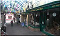
The Arcade, Ammanford
Ammanford arcade is now only half its original length. On 4th June 1977, the eastern half was completely gutted by a huge fire which also badly damaged the adjacent Palace Cinema leading to the remains of the upper arcade and cinema being demolished and is now a car park.
Image: © Hywel Williams
Taken: 29 Dec 2014
0.08 miles
9
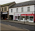
iSmooth and Mencap in Ammanford
iSmooth Community Cafe & Coffee Lounge is on the right. Amman Valley Mencap is next door.
Viewed across the A483 College Street.
Image: © Jaggery
Taken: 11 Feb 2015
0.09 miles
10
Bethany Methodist Church
On the skyline, the mast Image on top of the moors is just visible.
Image: © Marion Phillips
Taken: 4 Mar 2010
0.09 miles