IMAGES TAKEN NEAR TO
Wernddu Road, AMMANFORD, SA18 2US
Introduction
This page details the photographs taken nearby to Wernddu Road, SA18 2US by members of the Geograph project.
The Geograph project started in 2005 with the aim of publishing, organising and preserving representative images for every square kilometre of Great Britain, Ireland and the Isle of Man.

There are currently over 7.5m images from over14,400 individuals and you can help contribute to the project by visiting https://www.geograph.org.uk
Image Map
Images are licensed for reuse under creativecommons.org/licenses/by-sa/2.0
Notes
- Clicking on the map will re-center to the selected point.
- The higher the marker number, the further away the image location is from the centre of the postcode.
Image Listing (4 Images Found)
Images are licensed for reuse under creativecommons.org/licenses/by-sa/2.0
Image
Details
Distance
1

Trac Seiclo Pontaman Cycle Track
Cerddwyr yn dilyn trac seiclo o Lanaman at Bontaman.
Walkers following a cycle track from Glanaman (trans. Aman riverside) to Pontaman (Aman bridge)
Image: © Alan Richards
Taken: 9 Dec 2012
0.15 miles
2

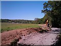
Construction of new cycle path
A new cycle path is under construction which will extend an existing cycle route (National Route 437) that runs up the Amman Valley with Ammanford.
Image: © Hywel Williams
Taken: 23 May 2010
0.17 miles
3
Cycle Path Construction
For a number of years, a "cycle path", part of the SUSTRANS network has existed between Ammanford and Garnant that had no start or destination - you could only access it via a narrow suspension bridge over the river Amman.Image
Work has since been done to extend this path up the Amman Valley but for a while it stopped about 1 kilometre short of Ammanford. Now, work is underway to complete the rest of this path. This is listed as National Route 437 and will shortly start from just west of Pontamman bridge to Glanamman with a view to eventually extending the route all the way to Brynamman.
Planning documents also suggest that this work is also being carried out to re-route existing public rights of way routes away from nearby farm buildings by providing new clearly defined paths that replace the ill defined (and in some cases almost impassable) current routes.
Image: © Hywel Williams
Taken: 23 May 2010
0.21 miles
4
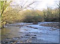
Island in the River Amman
Looking upstream from the north bank of the River Amman two divergent streams can be seen rejoining each other around the tip of an island in the middle of the river.
Image: © Nigel Davies
Taken: 19 Nov 2005
0.25 miles