IMAGES TAKEN NEAR TO
Parc Penrhiw, AMMANFORD, SA18 2SP
Introduction
This page details the photographs taken nearby to Parc Penrhiw, SA18 2SP by members of the Geograph project.
The Geograph project started in 2005 with the aim of publishing, organising and preserving representative images for every square kilometre of Great Britain, Ireland and the Isle of Man.

There are currently over 7.5m images from over14,400 individuals and you can help contribute to the project by visiting https://www.geograph.org.uk
Image Map (Loading...)


Getting Data...Please wait
Leaflet Map data © OpenStreetMap
Images are licensed for reuse under creativecommons.org/licenses/by-sa/2.0
Notes
- Clicking on the map will re-center to the selected point.
- The higher the marker number, the further away the image location is from the centre of the postcode.
Image Listing (5 Images Found)
Images are licensed for reuse under creativecommons.org/licenses/by-sa/2.0
Image
Details
Distance
1
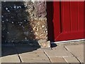
Ordnance Survey Cut Mark
This OS cut mark can be found on Glyn-yr-eithin. It marks a point 63.648m above mean sea level.
Image: © Adrian Dust
Taken: 3 Aug 2021
0.08 miles
2
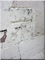
Ordnance Survey Cut Mark
This heavily over painted OS Cut Mark can be found on the front of No1 Rhos Y Fedwen. It marks a point 37.4234m above mean sea level.
Image: © Adrian Dust
Taken: 13 Jul 2013
0.13 miles
3
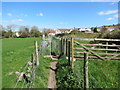
Llwybr Quika Path
Llwybr cyhoeddus sy'n cysylltu Rhyd y Maerdy ger Pantyffynon â Heol Betws. Dywedir i 'quika' deillio naill ai o 'Coedcae> coeca' neu 'quickway'.
A public footpath linking Rhyd y Maerdy near Pantyffynnon (trans. spring / well hollow) with Betws Road. The name 'quika' is either derived form 'coed cae> coeca' or 'quick way'.
Image: © Alan Richards
Taken: 14 Apr 2014
0.20 miles
4
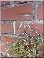
Ordnance Survey Cut Mark
This OS Cut Mark can be found on a brick pillar at the end of the wall of the cemetery to the west of Betws Road. It marks a point 34.9600m above mean sea level.
Image: © Adrian Dust
Taken: 13 Jul 2013
0.23 miles
5
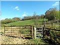
Llwybr Betws Path
Llwybr cyhoeddus sy'n cysylltu Heol y Betws â Ffordd y Cyrnol. Gerllaw saif anhedd-dy Bryn yr Eithin.
A public footpath which links Betws Road with Colonel Road. Nearby is a property known as Bryn yr Eithin (trans. Gorse Hill)
Image: © Alan Richards
Taken: 14 Apr 2014
0.25 miles