IMAGES TAKEN NEAR TO
Garnswllt, AMMANFORD, SA18 2SB
Introduction
This page details the photographs taken nearby to SA18 2SB by members of the Geograph project.
The Geograph project started in 2005 with the aim of publishing, organising and preserving representative images for every square kilometre of Great Britain, Ireland and the Isle of Man.

There are currently over 7.5m images from over14,400 individuals and you can help contribute to the project by visiting https://www.geograph.org.uk
Image Map
Images are licensed for reuse under creativecommons.org/licenses/by-sa/2.0
Notes
- Clicking on the map will re-center to the selected point.
- The higher the marker number, the further away the image location is from the centre of the postcode.
Image Listing (2 Images Found)
Images are licensed for reuse under creativecommons.org/licenses/by-sa/2.0
Image
Details
Distance
1
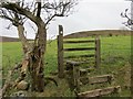
Sticil ar bwys Ynys-ger-gathan / Stile near Ynys-ger-gathan
Sticil ar lwybr cyhoeddus sy'n dringo'r tyle o bentre Garnswllt at y mynydd agored.
A stile on a public footpath ascending the hill from Garnswllt (trans. cairn of treasure) village towards the open moorland
Image: © Alan Richards
Taken: 10 Jan 2014
0.15 miles
2
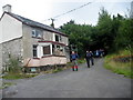
Cwm y Felin
Anhedd-dy o'r enw Cwm y Felin a saif uwchben Afon Cathan gerllaw.
A property known as Cwm y Felin (trans. Valley of the mill) located above the nearby Cathan River
Image: © Alan Richards
Taken: 20 Aug 2006
0.16 miles