IMAGES TAKEN NEAR TO
Rhodfa Frank, AMMANFORD, SA18 2QE
Introduction
This page details the photographs taken nearby to Rhodfa Frank, SA18 2QE by members of the Geograph project.
The Geograph project started in 2005 with the aim of publishing, organising and preserving representative images for every square kilometre of Great Britain, Ireland and the Isle of Man.

There are currently over 7.5m images from over14,400 individuals and you can help contribute to the project by visiting https://www.geograph.org.uk
Image Map (Loading...)


Getting Data...Please wait
Leaflet Map data © OpenStreetMap
Images are licensed for reuse under creativecommons.org/licenses/by-sa/2.0
Notes
- Clicking on the map will re-center to the selected point.
- The higher the marker number, the further away the image location is from the centre of the postcode.
Image Listing (34 Images Found)
Images are licensed for reuse under creativecommons.org/licenses/by-sa/2.0
Image
Details
Distance
1
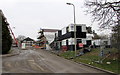
Construction site at the northern end of Rhodfa Frank in Ammanford
Viewed in February 2015. A Google Earth Street View taken in July 2011 shows a road and green fields here.
Image: © Jaggery
Taken: 11 Feb 2015
0.10 miles
2
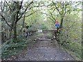
Derelict Bridge over Loughor
This bridge used to continue Shand's Road towards Llandybie, however years of neglect have now rendered it quite derelict and dangerous to cross. The road was once a mineral railway line (part of the Mountain Branch from the Mid Wales line) but in the late 1960s, a road was built to allow private access to opencast workings. Since the opencasts have now long gone, the road is now abandoned. It can be followed (from the other side of the bridge) all the way to just outside Llandybie where it would have crossed the B4556 into the now landscaped opencast workings.
Image: © Hywel Williams
Taken: 4 Nov 2006
0.11 miles
3
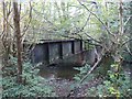
Derelict Railway Bridge
A derelict railway bridge is one of the only signs left that a railway used to run along this route. Not part of the main railway itself, which ran along the course occupied today by a private road, this bridge served a short siding used by the nearby tinplate works and mines.
Image: © Hywel Williams
Taken: 4 Nov 2006
0.11 miles
4
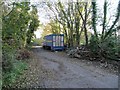
Derelict Vehicles on Shand's Road
There are quite a few derelict vehicles parked along this stretch of Shand's Road, a private mineral road built along the course of an old railway branch. The vehicles are probably part of the large scrap yard that now occupies the old tinplate works, just beyond.
Image: © Hywel Williams
Taken: 4 Nov 2006
0.11 miles
5
Llwybr Glyntai Fawr Path
Llwybr cyhoeddus yn mynd o gyfeiriad Ffarm Glyntai Fawr tuag at Heol Dyffryn.
A public footpath heading towards Dyffryn Road from the direction of Glyntai Fawr Farm.
Image: © Alan Richards
Taken: 13 Sep 2014
0.11 miles
6
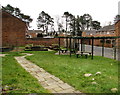
Community area in a suburban corner of Ammanford
On the corner of Rhodfa Frank and Heol Haydn.
Image: © Jaggery
Taken: 11 Feb 2015
0.14 miles
7
Heol Haydn, Gwyn Fryn Estate, Ammanford
On the east side of Rhodfa Frank.
Image: © Jaggery
Taken: 11 Feb 2015
0.16 miles
8
Wet streaks on Rhodfa Frank, Ammanford
A street cleaning vehicle http://www.geograph.org.uk/photo/4345401 passed by a few seconds earlier.
Image: © Jaggery
Taken: 11 Feb 2015
0.16 miles
9
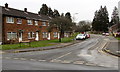
Rhodfa Frank, Gwyn Fryn Estate, Ammanford
On the north side of Station Road and Dyffryn Road. Rhodfa is Welsh for avenue.
Image: © Jaggery
Taken: 11 Feb 2015
0.16 miles
10
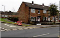
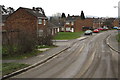
Station Road houses, Ammanford
HEOL-YR-ORSAF is more prominent than STATION ROAD in the bilingual street name sign.
After a few hours in Pontarddulais in the City and County of Swansea earlier in the day, I noticed the greater prominence given to the Welsh language in Ammanford in Carmarthenshire. In the 2001 Census, 75% of the population in Ammanford stated that they were competent in the Welsh language.
Image: © Jaggery
Taken: 11 Feb 2015
0.16 miles