IMAGES TAKEN NEAR TO
Argoed Road, AMMANFORD, SA18 2PR
Introduction
This page details the photographs taken nearby to Argoed Road, SA18 2PR by members of the Geograph project.
The Geograph project started in 2005 with the aim of publishing, organising and preserving representative images for every square kilometre of Great Britain, Ireland and the Isle of Man.

There are currently over 7.5m images from over14,400 individuals and you can help contribute to the project by visiting https://www.geograph.org.uk
Image Map
Images are licensed for reuse under creativecommons.org/licenses/by-sa/2.0
Notes
- Clicking on the map will re-center to the selected point.
- The higher the marker number, the further away the image location is from the centre of the postcode.
Image Listing (3 Images Found)
Images are licensed for reuse under creativecommons.org/licenses/by-sa/2.0
Image
Details
Distance
1
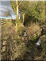
Two rivulets
Streams converging at Betws - tributaries of Afon Aman.
Image: © Alan Hughes
Taken: 10 Feb 2021
0.04 miles
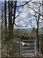
3
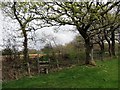
Llwybr Maerdy Mawr / Maerdy Mawr path
Sticil ar lwybr cyhoeddus sy'n cystylltu Ffarm Maerdy Mawr ag anhedd-dy Waun Bryn Cam.
A stile on a footpath linking Maerdy Mawr Farm (poss. home farm) with a property known as Waun Bryn Cam (crooked hill fen)
Image: © Alan Richards
Taken: 17 Apr 2014
0.20 miles